You are here: Home > Network List > II - Global Seismograph Network (GSN - IRIS/IDA) Stations List
> Station PFO Pinon Flat, California, USA > Earthquake Result Viewer
PFO Pinon Flat, California, USA - Earthquake Result Viewer
*The percent match for this event was below the threshold and hence no stack was calculated.
| Earthquake location: |
Kuril Islands |
| Earthquake latitude/longitude: |
48.8/154.8 |
| Earthquake time(UTC): |
2011/08/04 (216) 13:51:34 GMT |
| Earthquake Depth: |
36 km |
| Earthquake Magnitude: |
6.0 MB, 5.8 MS, 6.1 MW, 6.0 MW |
| Earthquake Catalog/Contributor: |
WHDF/NEIC |
|
| Network: |
II Global Seismograph Network (GSN - IRIS/IDA) |
| Station: |
PFO Pinon Flat, California, USA |
| Lat/Lon: |
33.61 N/116.46 W |
| Elevation: |
1280 m |
|
| Distance: |
64.8 deg |
| Az: |
67.203 deg |
| Baz: |
313.12 deg |
| Ray Param: |
$rayparam |
*The percent match for this event was below the threshold and hence was not used in the summary stack. |
|
| Radial Match: |
69.96243 % |
| Radial Bump: |
400 |
| Transverse Match: |
55.646732 % |
| Transverse Bump: |
400 |
| SOD ConfigId: |
558545 |
| Insert Time: |
2013-09-19 00:21:42.393 +0000 |
| GWidth: |
2.5 |
| Max Bumps: |
400 |
| Tol: |
0.001 |
|
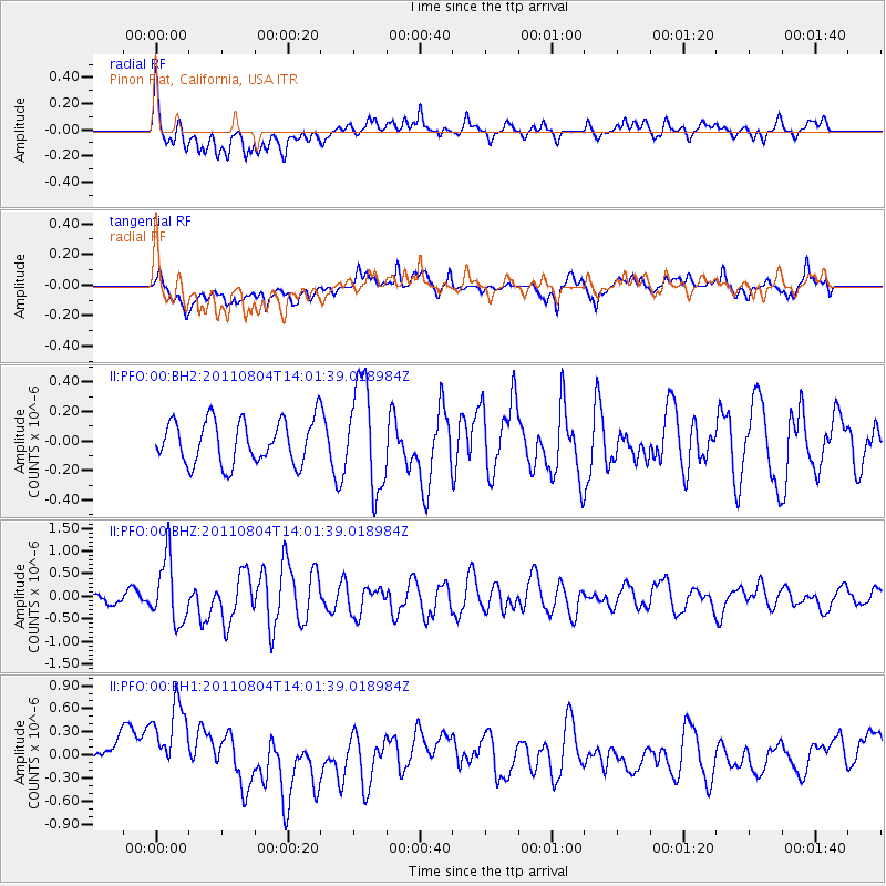
Signal To Noise
| Channel | StoN | STA | LTA |
| II:PFO:00:BHZ:20110804T14:01:39.018984Z | 4.4071198 | 7.0405486E-7 | 1.5975397E-7 |
| II:PFO:00:BH1:20110804T14:01:39.018984Z | 3.2442286 | 5.594906E-7 | 1.7245722E-7 |
| II:PFO:00:BH2:20110804T14:01:39.018984Z | 2.4203289 | 3.5593132E-7 | 1.4705907E-7 |
| Arrivals |
| Ps | |
| PpPs | |
| PsPs/PpSs | |


