You are here: Home > Network List > NX - Nanometrics Research Network Stations List
> Station STN19 Seismic station 19 > Earthquake Result Viewer
STN19 Seismic station 19 - Earthquake Result Viewer
| Earthquake location: |
Easter Island Region |
| Earthquake latitude/longitude: |
-26.6/-114.5 |
| Earthquake time(UTC): |
2014/09/06 (249) 06:53:13 GMT |
| Earthquake Depth: |
10 km |
| Earthquake Magnitude: |
6.1 MB |
| Earthquake Catalog/Contributor: |
NEIC PDE/NEIC COMCAT |
|
| Network: |
NX Nanometrics Research Network |
| Station: |
STN19 Seismic station 19 |
| Lat/Lon: |
36.68 N/97.90 W |
| Elevation: |
337 m |
|
| Distance: |
64.9 deg |
| Az: |
14.653 deg |
| Baz: |
196.361 deg |
| Ray Param: |
0.058642767 |
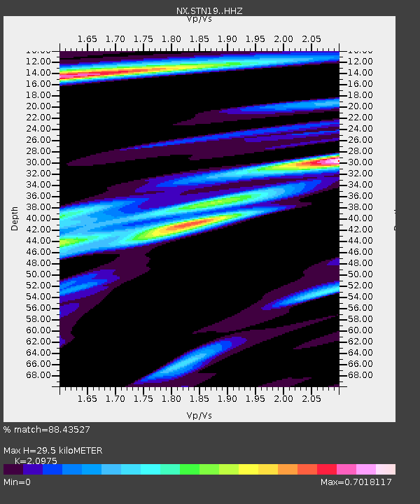
| Estimated Moho Depth: |
29.5 km |
| Estimated Crust Vp/Vs: |
2.10 |
| Assumed Crust Vp: |
6.483 km/s |
| Estimated Crust Vs: |
3.091 km/s |
| Estimated Crust Poisson's Ratio: |
0.35 |
|
| Radial Match: |
88.43527 % |
| Radial Bump: |
400 |
| Transverse Match: |
73.763306 % |
| Transverse Bump: |
303 |
| SOD ConfigId: |
3390531 |
| Insert Time: |
2019-04-13 21:29:21.678 +0000 |
| GWidth: |
2.5 |
| Max Bumps: |
400 |
| Tol: |
0.001 |
|

Signal To Noise
| Channel | StoN | STA | LTA |
| NX:STN19: :HHZ:20140906T07:03:21.939993Z | 11.234287 | 1.8023494E-6 | 1.604329E-7 |
| NX:STN19: :HH1:20140906T07:03:21.939993Z | 4.925992 | 8.036836E-7 | 1.6315161E-7 |
| NX:STN19: :HH2:20140906T07:03:21.939993Z | 3.3828526 | 5.875852E-7 | 1.7369518E-7 |
| Arrivals |
| Ps | 5.2 SECOND |
| PpPs | 14 SECOND |
| PsPs/PpSs | 19 SECOND |


