You are here: Home > Network List > US - United States National Seismic Network Stations List
> Station PKME Peaks-Kenny State Park, Maine, USA > Earthquake Result Viewer
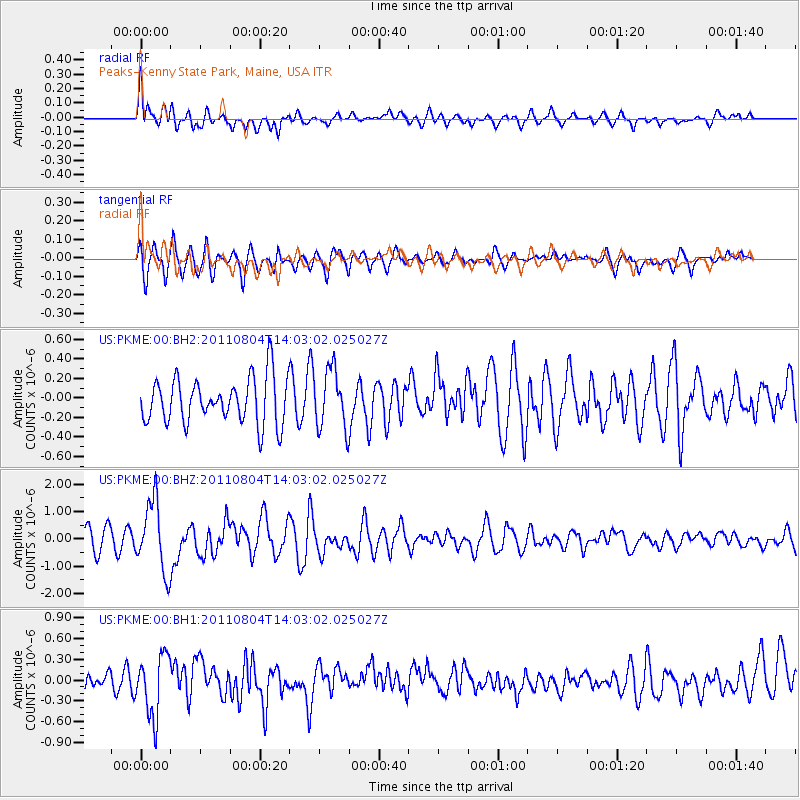
PKME Peaks-Kenny State Park, Maine, USA - Earthquake Result Viewer
*The percent match for this event was below the threshold and hence no stack was calculated.
| Earthquake location: |
Kuril Islands |
| Earthquake latitude/longitude: |
48.8/154.8 |
| Earthquake time(UTC): |
2011/08/04 (216) 13:51:34 GMT |
| Earthquake Depth: |
36 km |
| Earthquake Magnitude: |
6.0 MB, 5.8 MS, 6.1 MW, 6.0 MW |
| Earthquake Catalog/Contributor: |
WHDF/NEIC |
|
| Network: |
US United States National Seismic Network |
| Station: |
PKME Peaks-Kenny State Park, Maine, USA |
| Lat/Lon: |
45.26 N/69.29 W |
| Elevation: |
108 m |
|
| Distance: |
78.7 deg |
| Az: |
30.056 deg |
| Baz: |
332.056 deg |
| Ray Param: |
$rayparam |
*The percent match for this event was below the threshold and hence was not used in the summary stack. |
|
| Radial Match: |
65.28978 % |
| Radial Bump: |
400 |
| Transverse Match: |
75.498184 % |
| Transverse Bump: |
400 |
| SOD ConfigId: |
558545 |
| Insert Time: |
2013-09-19 00:25:01.919 +0000 |
| GWidth: |
2.5 |
| Max Bumps: |
400 |
| Tol: |
0.001 |
|
Signal To Noise
| Channel | StoN | STA | LTA |
| US:PKME:00:BHZ:20110804T14:03:02.025027Z | 3.3200285 | 1.2706247E-6 | 3.8271497E-7 |
| US:PKME:00:BH1:20110804T14:03:02.025027Z | 2.289092 | 4.417903E-7 | 1.9299806E-7 |
| US:PKME:00:BH2:20110804T14:03:02.025027Z | 1.3083206 | 3.0413136E-7 | 2.3245934E-7 |
| Arrivals |
| Ps | |
| PpPs | |
| PsPs/PpSs | |


