You are here: Home > Network List > US - United States National Seismic Network Stations List
> Station WMOK Wichita Mountains, Oklahoma, USA > Earthquake Result Viewer
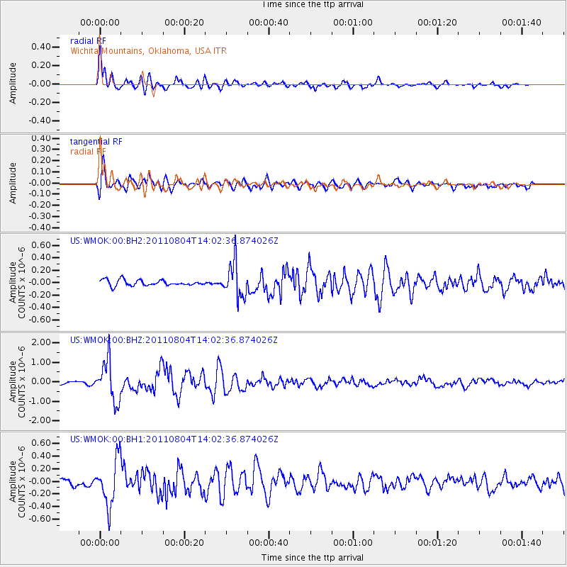
WMOK Wichita Mountains, Oklahoma, USA - Earthquake Result Viewer
*The percent match for this event was below the threshold and hence no stack was calculated.
| Earthquake location: |
Kuril Islands |
| Earthquake latitude/longitude: |
48.8/154.8 |
| Earthquake time(UTC): |
2011/08/04 (216) 13:51:34 GMT |
| Earthquake Depth: |
36 km |
| Earthquake Magnitude: |
6.0 MB, 5.8 MS, 6.1 MW, 6.0 MW |
| Earthquake Catalog/Contributor: |
WHDF/NEIC |
|
| Network: |
US United States National Seismic Network |
| Station: |
WMOK Wichita Mountains, Oklahoma, USA |
| Lat/Lon: |
34.74 N/98.78 W |
| Elevation: |
486 m |
|
| Distance: |
74.2 deg |
| Az: |
55.156 deg |
| Baz: |
318.816 deg |
| Ray Param: |
$rayparam |
*The percent match for this event was below the threshold and hence was not used in the summary stack. |
|
| Radial Match: |
86.957344 % |
| Radial Bump: |
400 |
| Transverse Match: |
87.74132 % |
| Transverse Bump: |
400 |
| SOD ConfigId: |
558545 |
| Insert Time: |
2013-09-19 00:25:20.844 +0000 |
| GWidth: |
2.5 |
| Max Bumps: |
400 |
| Tol: |
0.001 |
|
Signal To Noise
| Channel | StoN | STA | LTA |
| US:WMOK:00:BHZ:20110804T14:02:36.874026Z | 10.909339 | 1.0729793E-6 | 9.835421E-8 |
| US:WMOK:00:BH1:20110804T14:02:36.874026Z | 4.7480674 | 3.7776374E-7 | 7.956158E-8 |
| US:WMOK:00:BH2:20110804T14:02:36.874026Z | 6.0993037 | 2.8188677E-7 | 4.6216222E-8 |
| Arrivals |
| Ps | |
| PpPs | |
| PsPs/PpSs | |


