You are here: Home > Network List > II - Global Seismograph Network (GSN - IRIS/IDA) Stations List
> Station WRAB Tennant Creek, NT, Australia > Earthquake Result Viewer
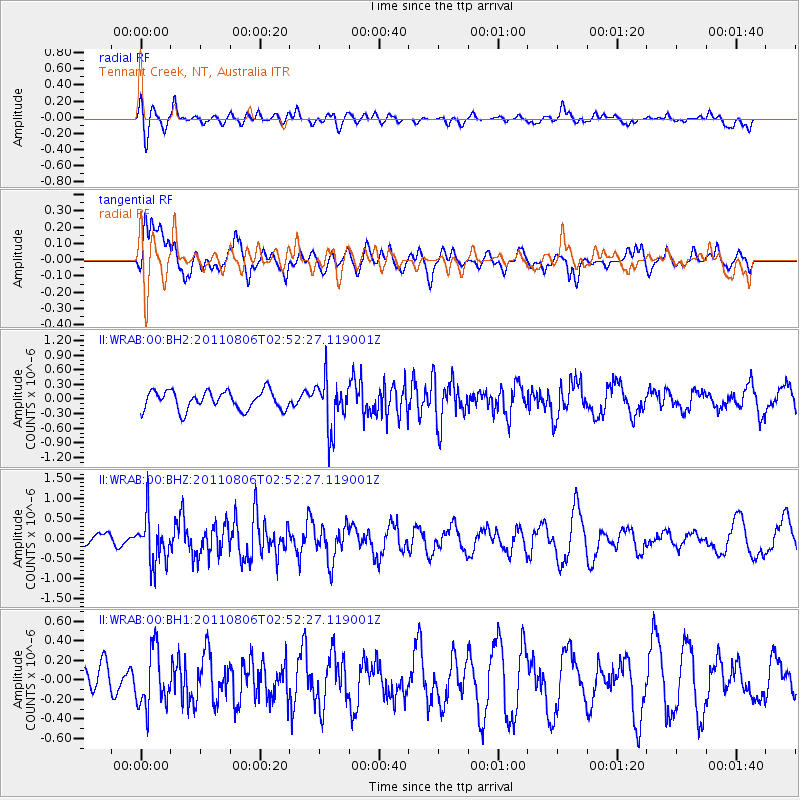
WRAB Tennant Creek, NT, Australia - Earthquake Result Viewer
*The percent match for this event was below the threshold and hence no stack was calculated.
| Earthquake location: |
Southern Sumatra, Indonesia |
| Earthquake latitude/longitude: |
-2.9/101.1 |
| Earthquake time(UTC): |
2011/08/06 (218) 02:45:55 GMT |
| Earthquake Depth: |
45 km |
| Earthquake Magnitude: |
5.6 MB, 5.0 MS, 5.4 MW, 5.3 MW |
| Earthquake Catalog/Contributor: |
WHDF/NEIC |
|
| Network: |
II Global Seismograph Network (GSN - IRIS/IDA) |
| Station: |
WRAB Tennant Creek, NT, Australia |
| Lat/Lon: |
19.93 S/134.36 E |
| Elevation: |
366 m |
|
| Distance: |
36.6 deg |
| Az: |
120.072 deg |
| Baz: |
293.268 deg |
| Ray Param: |
$rayparam |
*The percent match for this event was below the threshold and hence was not used in the summary stack. |
|
| Radial Match: |
63.490337 % |
| Radial Bump: |
400 |
| Transverse Match: |
68.93727 % |
| Transverse Bump: |
400 |
| SOD ConfigId: |
558545 |
| Insert Time: |
2013-09-19 00:27:44.605 +0000 |
| GWidth: |
2.5 |
| Max Bumps: |
400 |
| Tol: |
0.001 |
|
Signal To Noise
| Channel | StoN | STA | LTA |
| II:WRAB:00:BHZ:20110806T02:52:27.119001Z | 1.9991058 | 5.8748634E-7 | 2.9387454E-7 |
| II:WRAB:00:BH1:20110806T02:52:27.119001Z | 1.68144 | 2.9672356E-7 | 1.7646991E-7 |
| II:WRAB:00:BH2:20110806T02:52:27.119001Z | 2.6375864 | 5.132802E-7 | 1.9460222E-7 |
| Arrivals |
| Ps | |
| PpPs | |
| PsPs/PpSs | |


