You are here: Home > Network List > TO - Tectonic Observatory Stations List
> Station CC36 CCSE CC36 > Earthquake Result Viewer
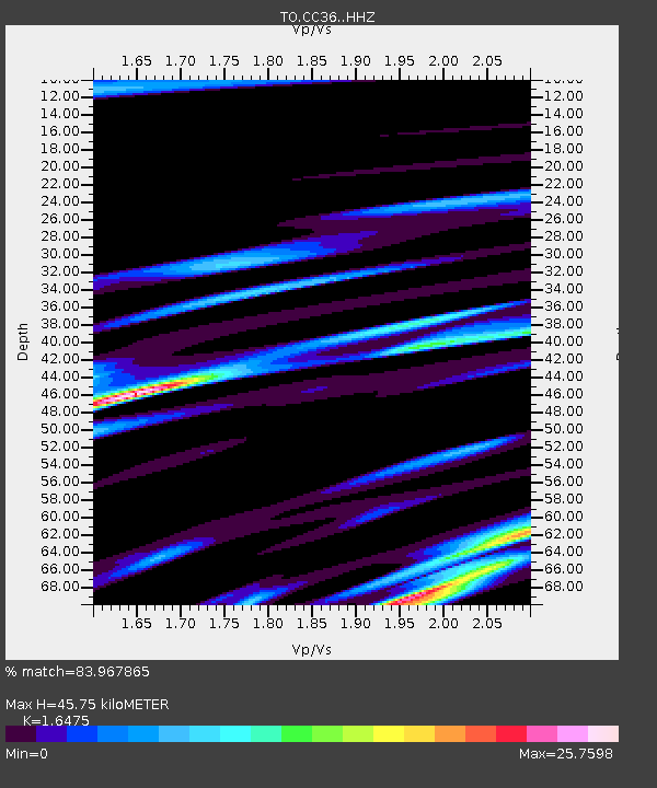
CC36 CCSE CC36 - Earthquake Result Viewer
| Earthquake location: |
Easter Island Region |
| Earthquake latitude/longitude: |
-26.6/-114.5 |
| Earthquake time(UTC): |
2014/09/06 (249) 06:53:13 GMT |
| Earthquake Depth: |
10 km |
| Earthquake Magnitude: |
6.1 MB |
| Earthquake Catalog/Contributor: |
NEIC PDE/NEIC COMCAT |
|
| Network: |
TO Tectonic Observatory |
| Station: |
CC36 CCSE CC36 |
| Lat/Lon: |
36.39 N/118.96 W |
| Elevation: |
265 m |
|
| Distance: |
62.8 deg |
| Az: |
355.914 deg |
| Baz: |
175.466 deg |
| Ray Param: |
0.0599764 |
| Estimated Moho Depth: |
45.75 km |
| Estimated Crust Vp/Vs: |
1.65 |
| Assumed Crust Vp: |
6.291 km/s |
| Estimated Crust Vs: |
3.819 km/s |
| Estimated Crust Poisson's Ratio: |
0.21 |
|
| Radial Match: |
83.967865 % |
| Radial Bump: |
351 |
| Transverse Match: |
78.36009 % |
| Transverse Bump: |
348 |
| SOD ConfigId: |
3390531 |
| Insert Time: |
2019-04-13 21:31:15.560 +0000 |
| GWidth: |
2.5 |
| Max Bumps: |
400 |
| Tol: |
0.001 |
|

Signal To Noise
| Channel | StoN | STA | LTA |
| TO:CC36: :HHZ:20140906T07:03:08.24999Z | 4.3908157 | 2.4445542E-8 | 5.5674265E-9 |
| TO:CC36: :HHN:20140906T07:03:08.24999Z | 4.118302 | 5.0752317E-7 | 1.2323602E-7 |
| TO:CC36: :HHE:20140906T07:03:08.24999Z | 1.8791165 | 1.7772982E-7 | 9.458159E-8 |
| Arrivals |
| Ps | 4.9 SECOND |
| PpPs | 18 SECOND |
| PsPs/PpSs | 23 SECOND |


