You are here: Home > Network List > US - United States National Seismic Network Stations List
> Station AMTX Amarillo, Texas, USA > Earthquake Result Viewer
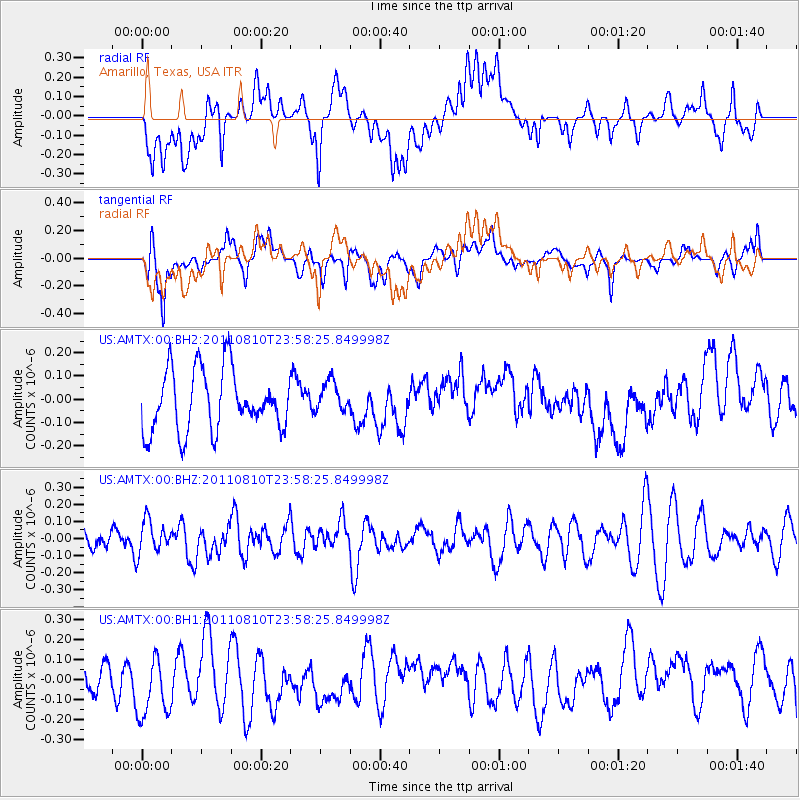
AMTX Amarillo, Texas, USA - Earthquake Result Viewer
*The percent match for this event was below the threshold and hence no stack was calculated.
| Earthquake location: |
Ascension Island Region |
| Earthquake latitude/longitude: |
-7.0/-12.6 |
| Earthquake time(UTC): |
2011/08/10 (222) 23:45:43 GMT |
| Earthquake Depth: |
10 km |
| Earthquake Magnitude: |
5.5 MB, 5.5 MS, 6.0 MW, 5.8 MW |
| Earthquake Catalog/Contributor: |
WHDF/NEIC |
|
| Network: |
US United States National Seismic Network |
| Station: |
AMTX Amarillo, Texas, USA |
| Lat/Lon: |
34.53 N/101.41 W |
| Elevation: |
1010 m |
|
| Distance: |
92.9 deg |
| Az: |
304.258 deg |
| Baz: |
96.459 deg |
| Ray Param: |
$rayparam |
*The percent match for this event was below the threshold and hence was not used in the summary stack. |
|
| Radial Match: |
51.04883 % |
| Radial Bump: |
400 |
| Transverse Match: |
51.569572 % |
| Transverse Bump: |
400 |
| SOD ConfigId: |
558545 |
| Insert Time: |
2013-09-19 00:38:06.228 +0000 |
| GWidth: |
2.5 |
| Max Bumps: |
400 |
| Tol: |
0.001 |
|
Signal To Noise
| Channel | StoN | STA | LTA |
| US:AMTX:00:BHZ:20110810T23:58:25.849998Z | 1.0909841 | 9.6181495E-8 | 8.816031E-8 |
| US:AMTX:00:BH1:20110810T23:58:25.849998Z | 2.4298148 | 1.696596E-7 | 6.982408E-8 |
| US:AMTX:00:BH2:20110810T23:58:25.849998Z | 0.5205818 | 6.833549E-8 | 1.3126753E-7 |
| Arrivals |
| Ps | |
| PpPs | |
| PsPs/PpSs | |


