You are here: Home > Network List > US - United States National Seismic Network Stations List
> Station COWI Conover, Wisconsin, USA > Earthquake Result Viewer
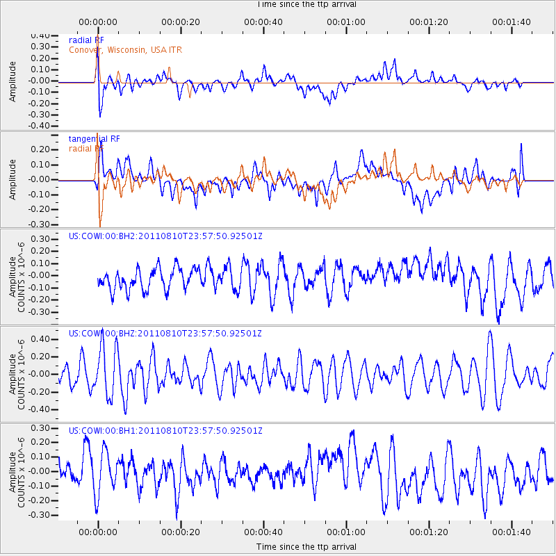
COWI Conover, Wisconsin, USA - Earthquake Result Viewer
*The percent match for this event was below the threshold and hence no stack was calculated.
| Earthquake location: |
Ascension Island Region |
| Earthquake latitude/longitude: |
-7.0/-12.6 |
| Earthquake time(UTC): |
2011/08/10 (222) 23:45:43 GMT |
| Earthquake Depth: |
10 km |
| Earthquake Magnitude: |
5.5 MB, 5.5 MS, 6.0 MW, 5.8 MW |
| Earthquake Catalog/Contributor: |
WHDF/NEIC |
|
| Network: |
US United States National Seismic Network |
| Station: |
COWI Conover, Wisconsin, USA |
| Lat/Lon: |
46.10 N/89.14 W |
| Elevation: |
523 m |
|
| Distance: |
85.8 deg |
| Az: |
317.275 deg |
| Baz: |
104.572 deg |
| Ray Param: |
$rayparam |
*The percent match for this event was below the threshold and hence was not used in the summary stack. |
|
| Radial Match: |
47.39698 % |
| Radial Bump: |
400 |
| Transverse Match: |
40.284992 % |
| Transverse Bump: |
400 |
| SOD ConfigId: |
558545 |
| Insert Time: |
2013-09-19 00:38:22.962 +0000 |
| GWidth: |
2.5 |
| Max Bumps: |
400 |
| Tol: |
0.001 |
|
Signal To Noise
| Channel | StoN | STA | LTA |
| US:COWI:00:BHZ:20110810T23:57:50.92501Z | 3.5087383 | 2.8914934E-7 | 8.2408356E-8 |
| US:COWI:00:BH1:20110810T23:57:50.92501Z | 1.3758283 | 1.5139578E-7 | 1.1003973E-7 |
| US:COWI:00:BH2:20110810T23:57:50.92501Z | 1.0724642 | 9.2609106E-8 | 8.63517E-8 |
| Arrivals |
| Ps | |
| PpPs | |
| PsPs/PpSs | |


