You are here: Home > Network List > II - Global Seismograph Network (GSN - IRIS/IDA) Stations List
> Station WRAB Tennant Creek, NT, Australia > Earthquake Result Viewer
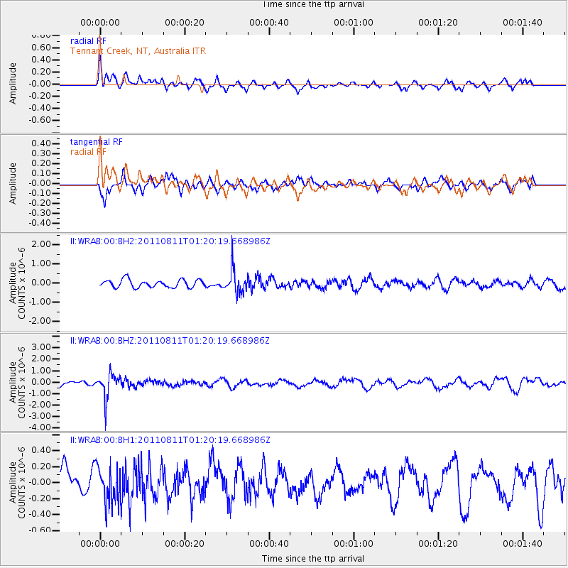
WRAB Tennant Creek, NT, Australia - Earthquake Result Viewer
*The percent match for this event was below the threshold and hence no stack was calculated.
| Earthquake location: |
South Of Fiji Islands |
| Earthquake latitude/longitude: |
-24.8/179.9 |
| Earthquake time(UTC): |
2011/08/11 (223) 01:13:41 GMT |
| Earthquake Depth: |
497 km |
| Earthquake Magnitude: |
5.7 MW |
| Earthquake Catalog/Contributor: |
NEIC PDE/NEIC PDE-M |
|
| Network: |
II Global Seismograph Network (GSN - IRIS/IDA) |
| Station: |
WRAB Tennant Creek, NT, Australia |
| Lat/Lon: |
19.93 S/134.36 E |
| Elevation: |
366 m |
|
| Distance: |
42.3 deg |
| Az: |
267.166 deg |
| Baz: |
105.238 deg |
| Ray Param: |
$rayparam |
*The percent match for this event was below the threshold and hence was not used in the summary stack. |
|
| Radial Match: |
54.777958 % |
| Radial Bump: |
400 |
| Transverse Match: |
65.67583 % |
| Transverse Bump: |
362 |
| SOD ConfigId: |
558545 |
| Insert Time: |
2013-09-19 00:40:00.672 +0000 |
| GWidth: |
2.5 |
| Max Bumps: |
400 |
| Tol: |
0.001 |
|
Signal To Noise
| Channel | StoN | STA | LTA |
| II:WRAB:00:BHZ:20110811T01:20:19.668986Z | 6.0037904 | 1.0176456E-6 | 1.6950051E-7 |
| II:WRAB:00:BH1:20110811T01:20:19.668986Z | 1.3372762 | 2.3645308E-7 | 1.7681693E-7 |
| II:WRAB:00:BH2:20110811T01:20:19.668986Z | 3.0453622 | 6.078059E-7 | 1.9958408E-7 |
| Arrivals |
| Ps | |
| PpPs | |
| PsPs/PpSs | |


