You are here: Home > Network List > US - United States National Seismic Network Stations List
> Station AMTX Amarillo, Texas, USA > Earthquake Result Viewer
AMTX Amarillo, Texas, USA - Earthquake Result Viewer
*The percent match for this event was below the threshold and hence no stack was calculated.
| Earthquake location: |
Eastern Honshu, Japan |
| Earthquake latitude/longitude: |
37.0/140.9 |
| Earthquake time(UTC): |
2011/08/11 (223) 18:22:04 GMT |
| Earthquake Depth: |
44 km |
| Earthquake Magnitude: |
6.0 MB, 5.3 MS, 5.9 MW, 5.9 MW |
| Earthquake Catalog/Contributor: |
WHDF/NEIC |
|
| Network: |
US United States National Seismic Network |
| Station: |
AMTX Amarillo, Texas, USA |
| Lat/Lon: |
34.53 N/101.41 W |
| Elevation: |
1010 m |
|
| Distance: |
88.2 deg |
| Az: |
47.0 deg |
| Baz: |
314.857 deg |
| Ray Param: |
$rayparam |
*The percent match for this event was below the threshold and hence was not used in the summary stack. |
|
| Radial Match: |
48.613132 % |
| Radial Bump: |
400 |
| Transverse Match: |
58.432552 % |
| Transverse Bump: |
400 |
| SOD ConfigId: |
558545 |
| Insert Time: |
2013-09-19 00:46:23.260 +0000 |
| GWidth: |
2.5 |
| Max Bumps: |
400 |
| Tol: |
0.001 |
|
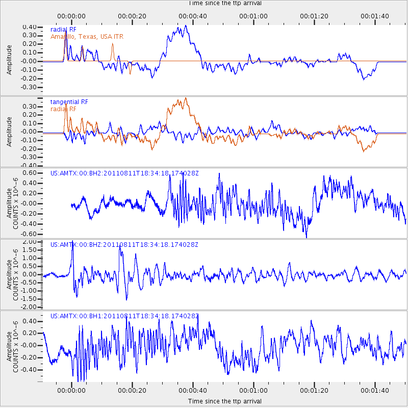
Signal To Noise
| Channel | StoN | STA | LTA |
| US:AMTX:00:BHZ:20110811T18:34:18.174028Z | 10.140557 | 8.023511E-7 | 7.9122984E-8 |
| US:AMTX:00:BH1:20110811T18:34:18.174028Z | 2.5496376 | 3.3370347E-7 | 1.3088271E-7 |
| US:AMTX:00:BH2:20110811T18:34:18.174028Z | 2.42855 | 2.674572E-7 | 1.101304E-7 |
| Arrivals |
| Ps | |
| PpPs | |
| PsPs/PpSs | |


