You are here: Home > Network List > XD14 - Illuminating the architecture of the greater Mount St. Helens magmatic systems f Stations List
> Station MK04 "Mount St Helens, WA" > Earthquake Result Viewer
MK04 "Mount St Helens, WA" - Earthquake Result Viewer
| Earthquake location: |
Easter Island Region |
| Earthquake latitude/longitude: |
-26.6/-114.5 |
| Earthquake time(UTC): |
2014/09/06 (249) 06:53:13 GMT |
| Earthquake Depth: |
10 km |
| Earthquake Magnitude: |
6.1 MB |
| Earthquake Catalog/Contributor: |
NEIC PDE/NEIC COMCAT |
|
| Network: |
XD Illuminating the architecture of the greater Mount St. Helens magmatic systems f |
| Station: |
MK04 "Mount St Helens, WA" |
| Lat/Lon: |
46.11 N/122.39 W |
| Elevation: |
482 m |
|
| Distance: |
72.8 deg |
| Az: |
354.229 deg |
| Baz: |
172.566 deg |
| Ray Param: |
0.053455498 |
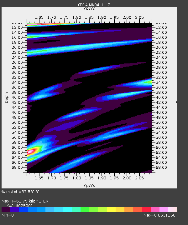
| Estimated Moho Depth: |
61.75 km |
| Estimated Crust Vp/Vs: |
1.60 |
| Assumed Crust Vp: |
6.566 km/s |
| Estimated Crust Vs: |
4.097 km/s |
| Estimated Crust Poisson's Ratio: |
0.18 |
|
| Radial Match: |
87.53131 % |
| Radial Bump: |
309 |
| Transverse Match: |
76.13785 % |
| Transverse Bump: |
400 |
| SOD ConfigId: |
3390531 |
| Insert Time: |
2019-04-13 21:32:24.048 +0000 |
| GWidth: |
2.5 |
| Max Bumps: |
400 |
| Tol: |
0.001 |
|

Signal To Noise
| Channel | StoN | STA | LTA |
| XD:MK04: :HHZ:20140906T07:04:10.439993Z | 11.662264 | 1.5052601E-6 | 1.29071E-7 |
| XD:MK04: :HHN:20140906T07:04:10.439993Z | 5.697889 | 5.227938E-7 | 9.17522E-8 |
| XD:MK04: :HHE:20140906T07:04:10.439993Z | 1.1177889 | 1.01140884E-7 | 9.048299E-8 |
| Arrivals |
| Ps | 5.9 SECOND |
| PpPs | 24 SECOND |
| PsPs/PpSs | 29 SECOND |


