You are here: Home > Network List > US - United States National Seismic Network Stations List
> Station DGMT Dagmar, Montana, USA > Earthquake Result Viewer
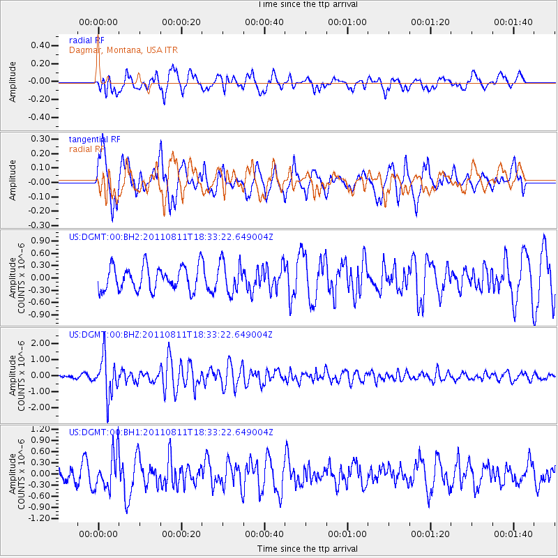
DGMT Dagmar, Montana, USA - Earthquake Result Viewer
*The percent match for this event was below the threshold and hence no stack was calculated.
| Earthquake location: |
Eastern Honshu, Japan |
| Earthquake latitude/longitude: |
37.0/140.9 |
| Earthquake time(UTC): |
2011/08/11 (223) 18:22:04 GMT |
| Earthquake Depth: |
44 km |
| Earthquake Magnitude: |
6.0 MB, 5.3 MS, 5.9 MW, 5.9 MW |
| Earthquake Catalog/Contributor: |
WHDF/NEIC |
|
| Network: |
US United States National Seismic Network |
| Station: |
DGMT Dagmar, Montana, USA |
| Lat/Lon: |
48.47 N/104.20 W |
| Elevation: |
0.0 m |
|
| Distance: |
77.1 deg |
| Az: |
38.259 deg |
| Baz: |
311.878 deg |
| Ray Param: |
$rayparam |
*The percent match for this event was below the threshold and hence was not used in the summary stack. |
|
| Radial Match: |
68.355675 % |
| Radial Bump: |
400 |
| Transverse Match: |
82.04281 % |
| Transverse Bump: |
400 |
| SOD ConfigId: |
558545 |
| Insert Time: |
2013-09-19 00:46:44.061 +0000 |
| GWidth: |
2.5 |
| Max Bumps: |
400 |
| Tol: |
0.001 |
|
Signal To Noise
| Channel | StoN | STA | LTA |
| US:DGMT:00:BHZ:20110811T18:33:22.649004Z | 12.884911 | 1.2401075E-6 | 9.6244946E-8 |
| US:DGMT:00:BH1:20110811T18:33:22.649004Z | 2.883275 | 4.9284745E-7 | 1.709332E-7 |
| US:DGMT:00:BH2:20110811T18:33:22.649004Z | 1.3123009 | 3.7956528E-7 | 2.8923645E-7 |
| Arrivals |
| Ps | |
| PpPs | |
| PsPs/PpSs | |


