You are here: Home > Network List > US - United States National Seismic Network Stations List
> Station WMOK Wichita Mountains, Oklahoma, USA > Earthquake Result Viewer
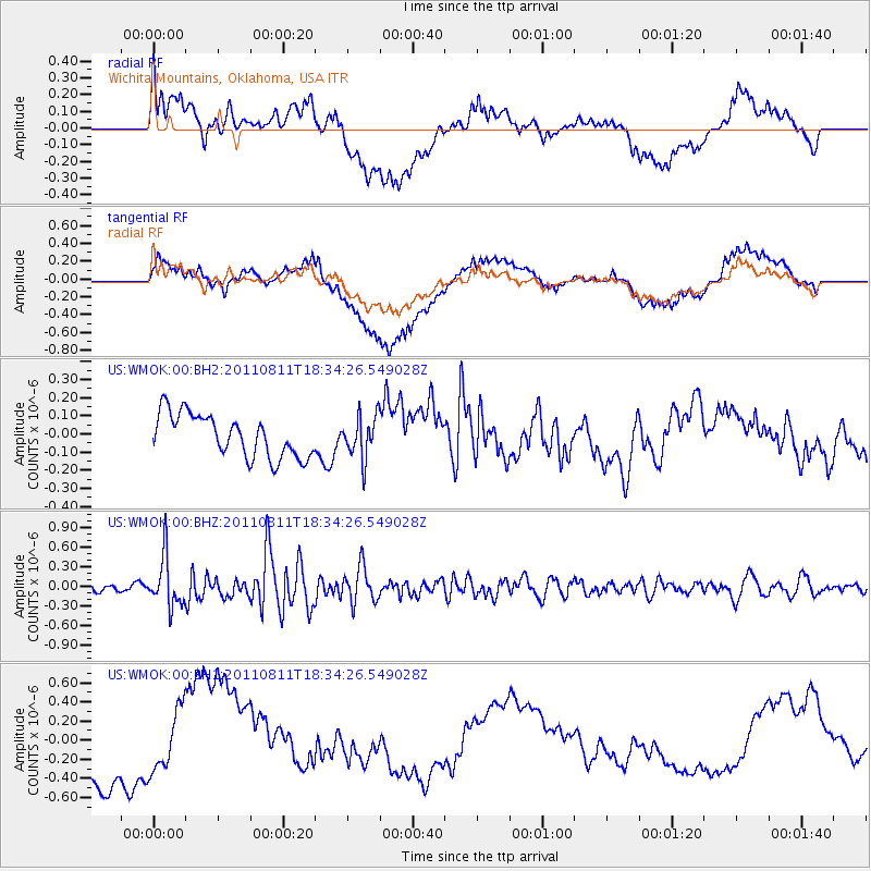
WMOK Wichita Mountains, Oklahoma, USA - Earthquake Result Viewer
*The percent match for this event was below the threshold and hence no stack was calculated.
| Earthquake location: |
Eastern Honshu, Japan |
| Earthquake latitude/longitude: |
37.0/140.9 |
| Earthquake time(UTC): |
2011/08/11 (223) 18:22:04 GMT |
| Earthquake Depth: |
44 km |
| Earthquake Magnitude: |
6.0 MB, 5.3 MS, 5.9 MW, 5.9 MW |
| Earthquake Catalog/Contributor: |
WHDF/NEIC |
|
| Network: |
US United States National Seismic Network |
| Station: |
WMOK Wichita Mountains, Oklahoma, USA |
| Lat/Lon: |
34.74 N/98.78 W |
| Elevation: |
486 m |
|
| Distance: |
89.6 deg |
| Az: |
45.307 deg |
| Baz: |
316.311 deg |
| Ray Param: |
$rayparam |
*The percent match for this event was below the threshold and hence was not used in the summary stack. |
|
| Radial Match: |
33.091743 % |
| Radial Bump: |
400 |
| Transverse Match: |
31.701555 % |
| Transverse Bump: |
400 |
| SOD ConfigId: |
558545 |
| Insert Time: |
2013-09-19 00:48:12.611 +0000 |
| GWidth: |
2.5 |
| Max Bumps: |
400 |
| Tol: |
0.001 |
|
Signal To Noise
| Channel | StoN | STA | LTA |
| US:WMOK:00:BHZ:20110811T18:34:26.549028Z | 8.088203 | 3.792577E-7 | 4.6890225E-8 |
| US:WMOK:00:BH1:20110811T18:34:26.549028Z | 0.96164966 | 3.1442934E-7 | 3.269687E-7 |
| US:WMOK:00:BH2:20110811T18:34:26.549028Z | 0.9973825 | 1.1699583E-7 | 1.1730287E-7 |
| Arrivals |
| Ps | |
| PpPs | |
| PsPs/PpSs | |


