You are here: Home > Network List > IU - Global Seismograph Network (GSN - IRIS/USGS) Stations List
> Station JOHN Johnston Island, USA > Earthquake Result Viewer
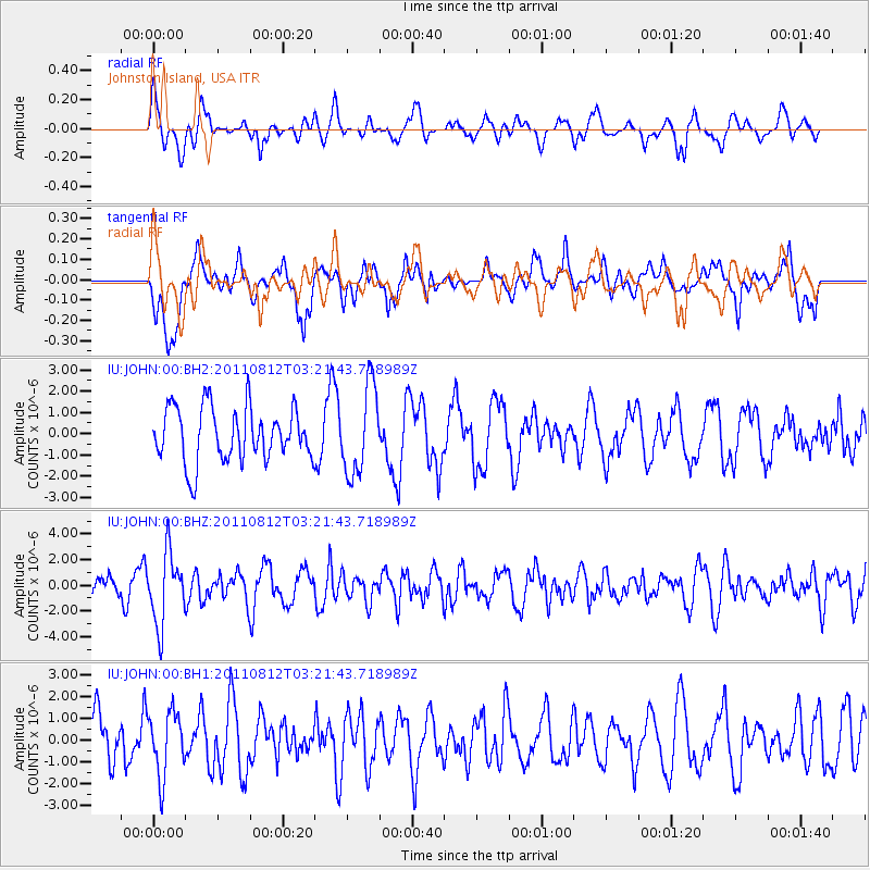
JOHN Johnston Island, USA - Earthquake Result Viewer
*The percent match for this event was below the threshold and hence no stack was calculated.
| Earthquake location: |
Fiji Islands Region |
| Earthquake latitude/longitude: |
-21.8/-177.0 |
| Earthquake time(UTC): |
2011/08/12 (224) 03:15:09 GMT |
| Earthquake Depth: |
219 km |
| Earthquake Magnitude: |
5.5 MW, 5.6 MW |
| Earthquake Catalog/Contributor: |
NEIC PDE/NEIC PDE-M |
|
| Network: |
IU Global Seismograph Network (GSN - IRIS/USGS) |
| Station: |
JOHN Johnston Island, USA |
| Lat/Lon: |
16.73 N/169.53 W |
| Elevation: |
2.0 m |
|
| Distance: |
39.0 deg |
| Az: |
11.451 deg |
| Baz: |
191.102 deg |
| Ray Param: |
$rayparam |
*The percent match for this event was below the threshold and hence was not used in the summary stack. |
|
| Radial Match: |
48.36069 % |
| Radial Bump: |
400 |
| Transverse Match: |
53.176495 % |
| Transverse Bump: |
400 |
| SOD ConfigId: |
558545 |
| Insert Time: |
2013-09-19 00:49:08.918 +0000 |
| GWidth: |
2.5 |
| Max Bumps: |
400 |
| Tol: |
0.001 |
|
Signal To Noise
| Channel | StoN | STA | LTA |
| IU:JOHN:00:BHZ:20110812T03:21:43.718989Z | 2.3603742 | 2.7562635E-6 | 1.1677231E-6 |
| IU:JOHN:00:BH1:20110812T03:21:43.718989Z | 0.9937175 | 1.4593436E-6 | 1.46857E-6 |
| IU:JOHN:00:BH2:20110812T03:21:43.718989Z | 1.6260056 | 2.0605062E-6 | 1.2672195E-6 |
| Arrivals |
| Ps | |
| PpPs | |
| PsPs/PpSs | |


