You are here: Home > Network List > US - United States National Seismic Network Stations List
> Station MNTX Cornudas Mountains, Texas, USA > Earthquake Result Viewer
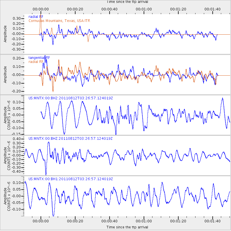
MNTX Cornudas Mountains, Texas, USA - Earthquake Result Viewer
*The percent match for this event was below the threshold and hence no stack was calculated.
| Earthquake location: |
Fiji Islands Region |
| Earthquake latitude/longitude: |
-21.8/-177.0 |
| Earthquake time(UTC): |
2011/08/12 (224) 03:15:09 GMT |
| Earthquake Depth: |
219 km |
| Earthquake Magnitude: |
5.5 MW, 5.6 MW |
| Earthquake Catalog/Contributor: |
NEIC PDE/NEIC PDE-M |
|
| Network: |
US United States National Seismic Network |
| Station: |
MNTX Cornudas Mountains, Texas, USA |
| Lat/Lon: |
31.70 N/105.38 W |
| Elevation: |
404 m |
|
| Distance: |
86.8 deg |
| Az: |
54.124 deg |
| Baz: |
242.056 deg |
| Ray Param: |
$rayparam |
*The percent match for this event was below the threshold and hence was not used in the summary stack. |
|
| Radial Match: |
50.081665 % |
| Radial Bump: |
400 |
| Transverse Match: |
66.6881 % |
| Transverse Bump: |
400 |
| SOD ConfigId: |
558545 |
| Insert Time: |
2013-09-19 00:50:16.147 +0000 |
| GWidth: |
2.5 |
| Max Bumps: |
400 |
| Tol: |
0.001 |
|
Signal To Noise
| Channel | StoN | STA | LTA |
| US:MNTX:00:BHZ:20110812T03:26:57.124019Z | 3.0642934 | 2.135551E-7 | 6.969147E-8 |
| US:MNTX:00:BH1:20110812T03:26:57.124019Z | 0.7512254 | 3.9621565E-8 | 5.274258E-8 |
| US:MNTX:00:BH2:20110812T03:26:57.124019Z | 0.6716501 | 4.719536E-8 | 7.0267774E-8 |
| Arrivals |
| Ps | |
| PpPs | |
| PsPs/PpSs | |


