You are here: Home > Network List > IU - Global Seismograph Network (GSN - IRIS/USGS) Stations List
> Station PMG Port Moresby, New Guinea > Earthquake Result Viewer
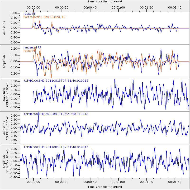
PMG Port Moresby, New Guinea - Earthquake Result Viewer
*The percent match for this event was below the threshold and hence no stack was calculated.
| Earthquake location: |
Kermadec Islands, New Zealand |
| Earthquake latitude/longitude: |
-30.6/-177.9 |
| Earthquake time(UTC): |
2011/08/13 (225) 07:14:47 GMT |
| Earthquake Depth: |
10 km |
| Earthquake Magnitude: |
5.5 MW |
| Earthquake Catalog/Contributor: |
NEIC PDE/NEIC PDE-M |
|
| Network: |
IU Global Seismograph Network (GSN - IRIS/USGS) |
| Station: |
PMG Port Moresby, New Guinea |
| Lat/Lon: |
9.40 S/147.16 E |
| Elevation: |
90 m |
|
| Distance: |
38.7 deg |
| Az: |
295.491 deg |
| Baz: |
127.893 deg |
| Ray Param: |
$rayparam |
*The percent match for this event was below the threshold and hence was not used in the summary stack. |
|
| Radial Match: |
57.59802 % |
| Radial Bump: |
400 |
| Transverse Match: |
48.523323 % |
| Transverse Bump: |
400 |
| SOD ConfigId: |
558545 |
| Insert Time: |
2013-09-19 00:53:20.296 +0000 |
| GWidth: |
2.5 |
| Max Bumps: |
400 |
| Tol: |
0.001 |
|
Signal To Noise
| Channel | StoN | STA | LTA |
| IU:PMG:00:BHZ:20110813T07:21:40.91901Z | 2.6197321 | 2.453892E-7 | 9.366958E-8 |
| IU:PMG:00:BH1:20110813T07:21:40.91901Z | 1.2166518 | 1.5761478E-7 | 1.2954797E-7 |
| IU:PMG:00:BH2:20110813T07:21:40.91901Z | 1.0749058 | 1.0663355E-7 | 9.9202694E-8 |
| Arrivals |
| Ps | |
| PpPs | |
| PsPs/PpSs | |


