You are here: Home > Network List > US - United States National Seismic Network Stations List
> Station AGMN Agassiz National Wildlife Refuge, Minnesota, USA > Earthquake Result Viewer
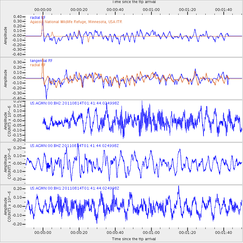
AGMN Agassiz National Wildlife Refuge, Minnesota, USA - Earthquake Result Viewer
*The percent match for this event was below the threshold and hence no stack was calculated.
| Earthquake location: |
North Of Ascension Island |
| Earthquake latitude/longitude: |
-1.3/-14.7 |
| Earthquake time(UTC): |
2011/08/14 (226) 01:29:39 GMT |
| Earthquake Depth: |
10 km |
| Earthquake Magnitude: |
5.7 MW, 5.6 MW |
| Earthquake Catalog/Contributor: |
NEIC PDE/NEIC PDE-M |
|
| Network: |
US United States National Seismic Network |
| Station: |
AGMN Agassiz National Wildlife Refuge, Minnesota, USA |
| Lat/Lon: |
48.30 N/95.86 W |
| Elevation: |
351 m |
|
| Distance: |
85.1 deg |
| Az: |
318.525 deg |
| Baz: |
97.451 deg |
| Ray Param: |
$rayparam |
*The percent match for this event was below the threshold and hence was not used in the summary stack. |
|
| Radial Match: |
44.55816 % |
| Radial Bump: |
400 |
| Transverse Match: |
62.078938 % |
| Transverse Bump: |
400 |
| SOD ConfigId: |
558545 |
| Insert Time: |
2013-09-19 00:57:55.920 +0000 |
| GWidth: |
2.5 |
| Max Bumps: |
400 |
| Tol: |
0.001 |
|
Signal To Noise
| Channel | StoN | STA | LTA |
| US:AGMN:00:BHZ:20110814T01:41:44.024998Z | 1.6304795 | 6.471716E-8 | 3.9692104E-8 |
| US:AGMN:00:BH1:20110814T01:41:44.024998Z | 0.8480784 | 5.4378262E-8 | 6.411938E-8 |
| US:AGMN:00:BH2:20110814T01:41:44.024998Z | 1.6290933 | 7.147934E-8 | 4.387676E-8 |
| Arrivals |
| Ps | |
| PpPs | |
| PsPs/PpSs | |


