You are here: Home > Network List > IU - Global Seismograph Network (GSN - IRIS/USGS) Stations List
> Station TRQA Tornquist, Argentina > Earthquake Result Viewer
TRQA Tornquist, Argentina - Earthquake Result Viewer
| Earthquake location: |
Ecuador |
| Earthquake latitude/longitude: |
-1.8/-76.9 |
| Earthquake time(UTC): |
2011/08/15 (227) 02:53:18 GMT |
| Earthquake Depth: |
177 km |
| Earthquake Magnitude: |
5.7 MB, 5.7 MW, 5.7 MW |
| Earthquake Catalog/Contributor: |
WHDF/NEIC |
|
| Network: |
IU Global Seismograph Network (GSN - IRIS/USGS) |
| Station: |
TRQA Tornquist, Argentina |
| Lat/Lon: |
38.06 S/61.98 W |
| Elevation: |
540 m |
|
| Distance: |
38.6 deg |
| Az: |
160.969 deg |
| Baz: |
335.615 deg |
| Ray Param: |
0.07482254 |
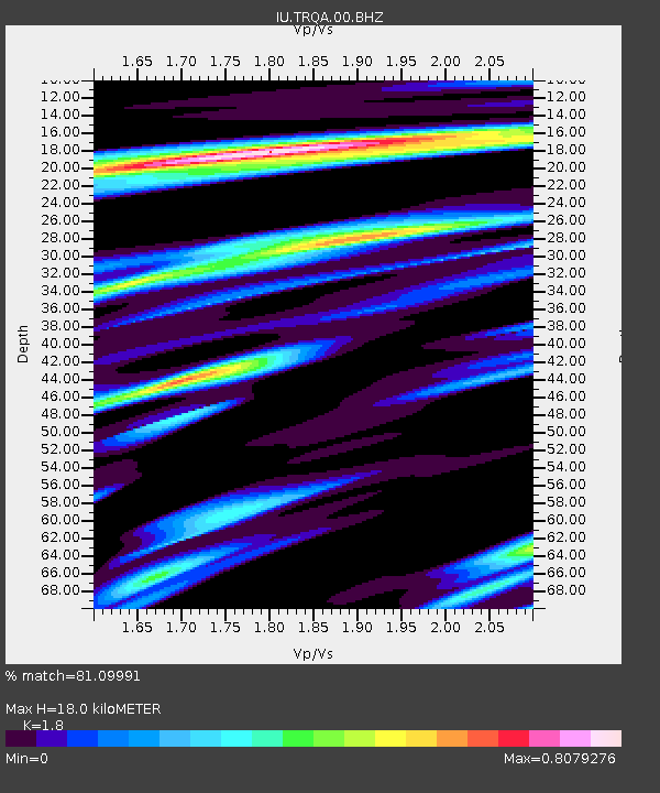
| Estimated Moho Depth: |
18.0 km |
| Estimated Crust Vp/Vs: |
1.80 |
| Assumed Crust Vp: |
6.472 km/s |
| Estimated Crust Vs: |
3.595 km/s |
| Estimated Crust Poisson's Ratio: |
0.28 |
|
| Radial Match: |
81.09991 % |
| Radial Bump: |
368 |
| Transverse Match: |
51.021923 % |
| Transverse Bump: |
400 |
| SOD ConfigId: |
558545 |
| Insert Time: |
2013-09-19 01:00:21.389 +0000 |
| GWidth: |
2.5 |
| Max Bumps: |
400 |
| Tol: |
0.001 |
|

Signal To Noise
| Channel | StoN | STA | LTA |
| IU:TRQA:00:BHZ:20110815T02:59:53.919003Z | 13.749962 | 1.6099212E-6 | 1.1708551E-7 |
| IU:TRQA:00:BH1:20110815T02:59:53.919003Z | 4.6975346 | 7.382941E-7 | 1.571663E-7 |
| IU:TRQA:00:BH2:20110815T02:59:53.919003Z | 3.1403584 | 6.3561055E-7 | 2.0240063E-7 |
| Arrivals |
| Ps | 2.4 SECOND |
| PpPs | 7.3 SECOND |
| PsPs/PpSs | 9.6 SECOND |


