You are here: Home > Network List > US - United States National Seismic Network Stations List
> Station AMTX Amarillo, Texas, USA > Earthquake Result Viewer
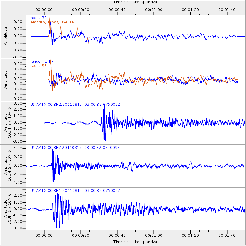
AMTX Amarillo, Texas, USA - Earthquake Result Viewer
*The percent match for this event was below the threshold and hence no stack was calculated.
| Earthquake location: |
Ecuador |
| Earthquake latitude/longitude: |
-1.8/-76.9 |
| Earthquake time(UTC): |
2011/08/15 (227) 02:53:18 GMT |
| Earthquake Depth: |
177 km |
| Earthquake Magnitude: |
5.7 MB, 5.7 MW, 5.7 MW |
| Earthquake Catalog/Contributor: |
WHDF/NEIC |
|
| Network: |
US United States National Seismic Network |
| Station: |
AMTX Amarillo, Texas, USA |
| Lat/Lon: |
34.53 N/101.41 W |
| Elevation: |
1010 m |
|
| Distance: |
42.8 deg |
| Az: |
329.772 deg |
| Baz: |
142.447 deg |
| Ray Param: |
$rayparam |
*The percent match for this event was below the threshold and hence was not used in the summary stack. |
|
| Radial Match: |
70.37052 % |
| Radial Bump: |
400 |
| Transverse Match: |
60.443317 % |
| Transverse Bump: |
400 |
| SOD ConfigId: |
558545 |
| Insert Time: |
2013-09-19 01:00:51.543 +0000 |
| GWidth: |
2.5 |
| Max Bumps: |
400 |
| Tol: |
0.001 |
|
Signal To Noise
| Channel | StoN | STA | LTA |
| US:AMTX:00:BHZ:20110815T03:00:32.075009Z | 8.599558 | 1.1319132E-6 | 1.3162459E-7 |
| US:AMTX:00:BH1:20110815T03:00:32.075009Z | 2.31721 | 2.4253845E-7 | 1.0466831E-7 |
| US:AMTX:00:BH2:20110815T03:00:32.075009Z | 3.088832 | 2.779247E-7 | 8.997728E-8 |
| Arrivals |
| Ps | |
| PpPs | |
| PsPs/PpSs | |


