You are here: Home > Network List > US - United States National Seismic Network Stations List
> Station EGMT Eagleton, Montana, USA > Earthquake Result Viewer
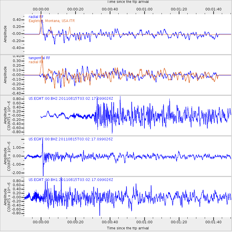
EGMT Eagleton, Montana, USA - Earthquake Result Viewer
*The percent match for this event was below the threshold and hence no stack was calculated.
| Earthquake location: |
Ecuador |
| Earthquake latitude/longitude: |
-1.8/-76.9 |
| Earthquake time(UTC): |
2011/08/15 (227) 02:53:18 GMT |
| Earthquake Depth: |
177 km |
| Earthquake Magnitude: |
5.7 MB, 5.7 MW, 5.7 MW |
| Earthquake Catalog/Contributor: |
WHDF/NEIC |
|
| Network: |
US United States National Seismic Network |
| Station: |
EGMT Eagleton, Montana, USA |
| Lat/Lon: |
48.02 N/109.75 W |
| Elevation: |
1055 m |
|
| Distance: |
57.3 deg |
| Az: |
334.359 deg |
| Baz: |
139.887 deg |
| Ray Param: |
$rayparam |
*The percent match for this event was below the threshold and hence was not used in the summary stack. |
|
| Radial Match: |
71.38993 % |
| Radial Bump: |
400 |
| Transverse Match: |
62.258663 % |
| Transverse Bump: |
400 |
| SOD ConfigId: |
558545 |
| Insert Time: |
2013-09-19 01:01:32.294 +0000 |
| GWidth: |
2.5 |
| Max Bumps: |
400 |
| Tol: |
0.001 |
|
Signal To Noise
| Channel | StoN | STA | LTA |
| US:EGMT:00:BHZ:20110815T03:02:17.099026Z | 9.308206 | 6.938995E-7 | 7.454708E-8 |
| US:EGMT:00:BH1:20110815T03:02:17.099026Z | 3.7549434 | 2.6478781E-7 | 7.0517125E-8 |
| US:EGMT:00:BH2:20110815T03:02:17.099026Z | 3.9003437 | 2.978875E-7 | 7.637468E-8 |
| Arrivals |
| Ps | |
| PpPs | |
| PsPs/PpSs | |


