You are here: Home > Network List > IU - Global Seismograph Network (GSN - IRIS/USGS) Stations List
> Station RSSD Black Hills, South Dakota, USA > Earthquake Result Viewer
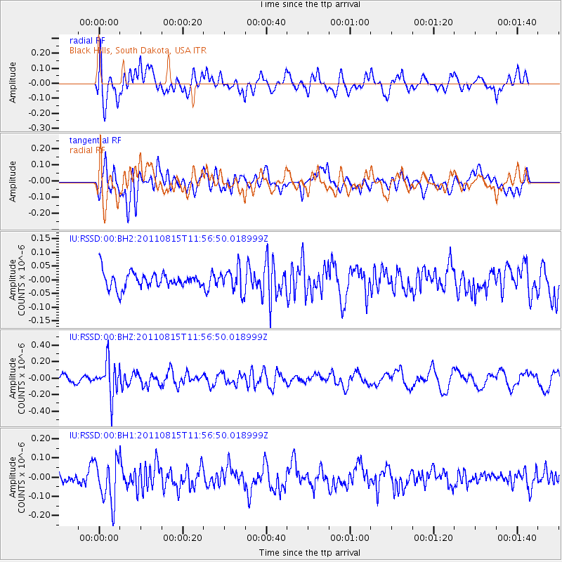
RSSD Black Hills, South Dakota, USA - Earthquake Result Viewer
*The percent match for this event was below the threshold and hence no stack was calculated.
| Earthquake location: |
Volcano Islands, Japan Region |
| Earthquake latitude/longitude: |
22.6/143.0 |
| Earthquake time(UTC): |
2011/08/15 (227) 11:44:38 GMT |
| Earthquake Depth: |
132 km |
| Earthquake Magnitude: |
5.6 MB |
| Earthquake Catalog/Contributor: |
NEIC PDE/NEIC PDE-M |
|
| Network: |
IU Global Seismograph Network (GSN - IRIS/USGS) |
| Station: |
RSSD Black Hills, South Dakota, USA |
| Lat/Lon: |
44.12 N/104.04 W |
| Elevation: |
2090 m |
|
| Distance: |
89.6 deg |
| Az: |
41.554 deg |
| Baz: |
301.697 deg |
| Ray Param: |
$rayparam |
*The percent match for this event was below the threshold and hence was not used in the summary stack. |
|
| Radial Match: |
47.430504 % |
| Radial Bump: |
400 |
| Transverse Match: |
57.09418 % |
| Transverse Bump: |
400 |
| SOD ConfigId: |
558545 |
| Insert Time: |
2013-09-19 01:04:43.108 +0000 |
| GWidth: |
2.5 |
| Max Bumps: |
400 |
| Tol: |
0.001 |
|
Signal To Noise
| Channel | StoN | STA | LTA |
| IU:RSSD:00:BHZ:20110815T11:56:50.018999Z | 3.6531622 | 2.103481E-7 | 5.7579733E-8 |
| IU:RSSD:00:BH1:20110815T11:56:50.018999Z | 2.9323618 | 1.1165358E-7 | 3.8076333E-8 |
| IU:RSSD:00:BH2:20110815T11:56:50.018999Z | 1.574633 | 4.51718E-8 | 2.8687191E-8 |
| Arrivals |
| Ps | |
| PpPs | |
| PsPs/PpSs | |


