You are here: Home > Network List > US - United States National Seismic Network Stations List
> Station DGMT Dagmar, Montana, USA > Earthquake Result Viewer
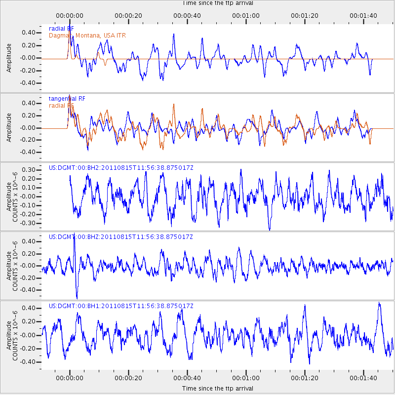
DGMT Dagmar, Montana, USA - Earthquake Result Viewer
*The percent match for this event was below the threshold and hence no stack was calculated.
| Earthquake location: |
Volcano Islands, Japan Region |
| Earthquake latitude/longitude: |
22.6/143.0 |
| Earthquake time(UTC): |
2011/08/15 (227) 11:44:38 GMT |
| Earthquake Depth: |
132 km |
| Earthquake Magnitude: |
5.6 MB |
| Earthquake Catalog/Contributor: |
NEIC PDE/NEIC PDE-M |
|
| Network: |
US United States National Seismic Network |
| Station: |
DGMT Dagmar, Montana, USA |
| Lat/Lon: |
48.47 N/104.20 W |
| Elevation: |
0.0 m |
|
| Distance: |
87.3 deg |
| Az: |
37.905 deg |
| Baz: |
301.483 deg |
| Ray Param: |
$rayparam |
*The percent match for this event was below the threshold and hence was not used in the summary stack. |
|
| Radial Match: |
62.695366 % |
| Radial Bump: |
400 |
| Transverse Match: |
54.083336 % |
| Transverse Bump: |
400 |
| SOD ConfigId: |
558545 |
| Insert Time: |
2013-09-19 01:05:24.038 +0000 |
| GWidth: |
2.5 |
| Max Bumps: |
400 |
| Tol: |
0.001 |
|
Signal To Noise
| Channel | StoN | STA | LTA |
| US:DGMT:00:BHZ:20110815T11:56:38.875017Z | 2.5573082 | 2.2165048E-7 | 8.667335E-8 |
| US:DGMT:00:BH1:20110815T11:56:38.875017Z | 1.335193 | 1.7033156E-7 | 1.2757073E-7 |
| US:DGMT:00:BH2:20110815T11:56:38.875017Z | 1.3460042 | 1.6577809E-7 | 1.2316312E-7 |
| Arrivals |
| Ps | |
| PpPs | |
| PsPs/PpSs | |


