You are here: Home > Network List > US - United States National Seismic Network Stations List
> Station EGMT Eagleton, Montana, USA > Earthquake Result Viewer
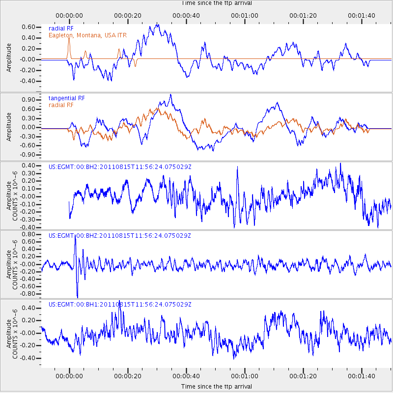
EGMT Eagleton, Montana, USA - Earthquake Result Viewer
*The percent match for this event was below the threshold and hence no stack was calculated.
| Earthquake location: |
Volcano Islands, Japan Region |
| Earthquake latitude/longitude: |
22.6/143.0 |
| Earthquake time(UTC): |
2011/08/15 (227) 11:44:38 GMT |
| Earthquake Depth: |
132 km |
| Earthquake Magnitude: |
5.6 MB |
| Earthquake Catalog/Contributor: |
NEIC PDE/NEIC PDE-M |
|
| Network: |
US United States National Seismic Network |
| Station: |
EGMT Eagleton, Montana, USA |
| Lat/Lon: |
48.02 N/109.75 W |
| Elevation: |
1055 m |
|
| Distance: |
84.2 deg |
| Az: |
40.129 deg |
| Baz: |
297.512 deg |
| Ray Param: |
$rayparam |
*The percent match for this event was below the threshold and hence was not used in the summary stack. |
|
| Radial Match: |
37.495598 % |
| Radial Bump: |
400 |
| Transverse Match: |
33.17873 % |
| Transverse Bump: |
400 |
| SOD ConfigId: |
558545 |
| Insert Time: |
2013-09-19 01:05:34.603 +0000 |
| GWidth: |
2.5 |
| Max Bumps: |
400 |
| Tol: |
0.001 |
|
Signal To Noise
| Channel | StoN | STA | LTA |
| US:EGMT:00:BHZ:20110815T11:56:24.075029Z | 5.739791 | 3.314428E-7 | 5.7744753E-8 |
| US:EGMT:00:BH1:20110815T11:56:24.075029Z | 1.6883175 | 2.0030836E-7 | 1.1864378E-7 |
| US:EGMT:00:BH2:20110815T11:56:24.075029Z | 1.2932948 | 1.244306E-7 | 9.621209E-8 |
| Arrivals |
| Ps | |
| PpPs | |
| PsPs/PpSs | |


