You are here: Home > Network List > YT07 - POLENET Stations List
> Station P061 P061 > Earthquake Result Viewer
P061 P061 - Earthquake Result Viewer
| Earthquake location: |
Easter Island Region |
| Earthquake latitude/longitude: |
-26.6/-114.5 |
| Earthquake time(UTC): |
2014/09/06 (249) 06:53:13 GMT |
| Earthquake Depth: |
10 km |
| Earthquake Magnitude: |
6.1 MB |
| Earthquake Catalog/Contributor: |
NEIC PDE/NEIC COMCAT |
|
| Network: |
YT POLENET |
| Station: |
P061 P061 |
| Lat/Lon: |
84.50 S/77.22 E |
| Elevation: |
1758 m |
|
| Distance: |
69.0 deg |
| Az: |
181.199 deg |
| Baz: |
168.803 deg |
| Ray Param: |
0.0559651 |
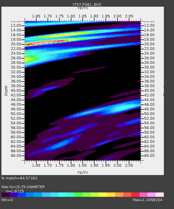
| Estimated Moho Depth: |
19.25 km |
| Estimated Crust Vp/Vs: |
1.67 |
| Assumed Crust Vp: |
6.261 km/s |
| Estimated Crust Vs: |
3.743 km/s |
| Estimated Crust Poisson's Ratio: |
0.22 |
|
| Radial Match: |
94.57262 % |
| Radial Bump: |
376 |
| Transverse Match: |
76.41096 % |
| Transverse Bump: |
400 |
| SOD ConfigId: |
3390531 |
| Insert Time: |
2019-04-13 21:34:11.495 +0000 |
| GWidth: |
2.5 |
| Max Bumps: |
400 |
| Tol: |
0.001 |
|

Signal To Noise
| Channel | StoN | STA | LTA |
| YT:P061: :BHZ:20140906T07:03:44.202993Z | 13.788935 | 2.638131E-6 | 1.9132233E-7 |
| YT:P061: :BHN:20140906T07:03:44.202993Z | 2.9701314 | 5.903645E-7 | 1.9876713E-7 |
| YT:P061: :BHE:20140906T07:03:44.202993Z | 1.3309346 | 2.4004694E-7 | 1.8035966E-7 |
| Arrivals |
| Ps | 2.1 SECOND |
| PpPs | 7.9 SECOND |
| PsPs/PpSs | 10 SECOND |


