You are here: Home > Network List > IU - Global Seismograph Network (GSN - IRIS/USGS) Stations List
> Station MAJO Matsushiro, Japan > Earthquake Result Viewer
MAJO Matsushiro, Japan - Earthquake Result Viewer
| Earthquake location: |
Ceram Sea |
| Earthquake latitude/longitude: |
-2.3/128.0 |
| Earthquake time(UTC): |
2011/08/16 (228) 11:03:57 GMT |
| Earthquake Depth: |
35 km |
| Earthquake Magnitude: |
6.1 MB, 5.7 MS, 6.0 MW, 5.9 MW |
| Earthquake Catalog/Contributor: |
WHDF/NEIC |
|
| Network: |
IU Global Seismograph Network (GSN - IRIS/USGS) |
| Station: |
MAJO Matsushiro, Japan |
| Lat/Lon: |
36.55 N/138.20 E |
| Elevation: |
405 m |
|
| Distance: |
39.8 deg |
| Az: |
12.867 deg |
| Baz: |
196.04 deg |
| Ray Param: |
0.0746823 |
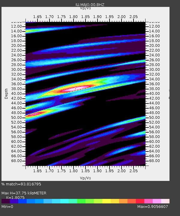
| Estimated Moho Depth: |
37.75 km |
| Estimated Crust Vp/Vs: |
1.81 |
| Assumed Crust Vp: |
6.461 km/s |
| Estimated Crust Vs: |
3.575 km/s |
| Estimated Crust Poisson's Ratio: |
0.28 |
|
| Radial Match: |
93.816795 % |
| Radial Bump: |
400 |
| Transverse Match: |
86.58548 % |
| Transverse Bump: |
400 |
| SOD ConfigId: |
558545 |
| Insert Time: |
2013-09-19 01:07:17.289 +0000 |
| GWidth: |
2.5 |
| Max Bumps: |
400 |
| Tol: |
0.001 |
|

Signal To Noise
| Channel | StoN | STA | LTA |
| IU:MAJO:00:BHZ:20110816T11:10:56.769Z | 10.331457 | 7.426849E-7 | 7.1885786E-8 |
| IU:MAJO:00:BH1:20110816T11:10:56.769Z | 6.3454876 | 4.3787307E-7 | 6.9005424E-8 |
| IU:MAJO:00:BH2:20110816T11:10:56.769Z | 2.7256906 | 1.8702384E-7 | 6.861521E-8 |
| Arrivals |
| Ps | 5.1 SECOND |
| PpPs | 15 SECOND |
| PsPs/PpSs | 20 SECOND |


