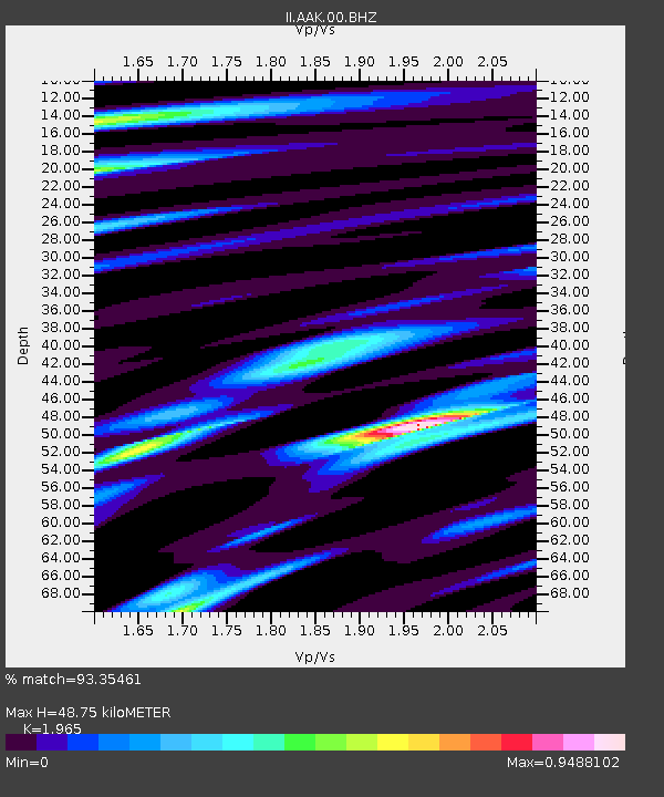
AAK Ala Archa, Kyrgyzstan - Earthquake Result Viewer
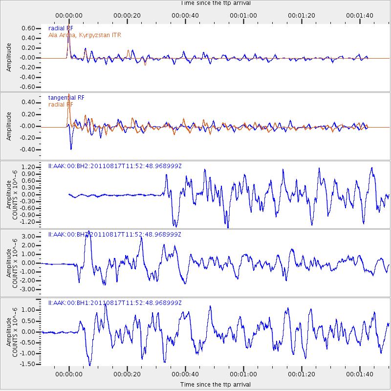
Earthquake location: Off East Coast Of Honshu, Japan
Earthquake latitude/longitude: 36.8/143.8
Earthquake time(UTC): 2011/08/17 (229) 11:44:08 GMT
Earthquake Depth: 9.0 km
Earthquake Magnitude: 6.1 MB, 5.8 MS, 6.2 MW, 6.1 MW
Earthquake Catalog/Contributor: WHDF/NEIC
Network: II Global Seismograph Network (GSN - IRIS/IDA)
Station: AAK Ala Archa, Kyrgyzstan
Lat/Lon: 42.64 N/74.49 E
Elevation: 1645 m
Distance: 52.3 deg
Az: 299.24 deg
Baz: 71.729 deg
Ray Param: 0.06686738
Estimated Moho Depth: 48.75 km
Estimated Crust Vp/Vs: 1.97
Assumed Crust Vp: 6.306 km/s
Estimated Crust Vs: 3.209 km/s
Estimated Crust Poisson's Ratio: 0.33
Radial Match: 93.35461 %
Radial Bump: 400
Transverse Match: 93.13126 %
Transverse Bump: 400
SOD ConfigId: 558545
Insert Time: 2013-09-19 01:10:49.553 +0000
GWidth: 2.5
Max Bumps: 400
Tol: 0.001

Signal To Noise

ChannelStoNSTALTA
II:AAK:00:BHZ:20110817T11:52:48.968999Z14.172766.494238E-74.582197E-8
II:AAK:00:BH1:20110817T11:52:48.968999Z9.848531.9920688E-72.0227068E-8
II:AAK:00:BH2:20110817T11:52:48.968999Z8.8794392.794321E-73.146957E-8
Arrivals
Ps7.8 SECOND
PpPs22 SECOND
PsPs/PpSs30 SECOND