RSSD Black Hills, South Dakota, USA - Earthquake Result Viewer
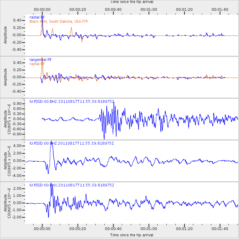
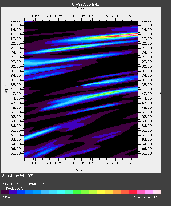
Earthquake location: Off East Coast Of Honshu, Japan
Earthquake latitude/longitude: 36.8/143.8
Earthquake time(UTC): 2011/08/17 (229) 11:44:08 GMT
Earthquake Depth: 9.0 km
Earthquake Magnitude: 6.1 MB, 5.8 MS, 6.2 MW, 6.1 MW
Earthquake Catalog/Contributor: WHDF/NEIC
Network: IU Global Seismograph Network (GSN - IRIS/USGS)
Station: RSSD Black Hills, South Dakota, USA
Lat/Lon: 44.12 N/104.04 W
Elevation: 2090 m
Distance: 78.8 deg
Az: 42.835 deg
Baz: 310.705 deg
Ray Param: 0.04942756
Estimated Moho Depth: 15.75 km
Estimated Crust Vp/Vs: 2.10
Assumed Crust Vp: 6.242 km/s
Estimated Crust Vs: 2.976 km/s
Estimated Crust Poisson's Ratio: 0.35
Radial Match: 96.4531 %
Radial Bump: 261
Transverse Match: 87.268196 %
Transverse Bump: 400
SOD ConfigId: 558545
Insert Time: 2013-09-19 01:12:06.194 +0000
GWidth: 2.5
Max Bumps: 400
Tol: 0.001

Signal To Noise

ChannelStoNSTALTA
IU:RSSD:00:BHZ:20110817T11:55:39.818975Z21.6170391.6265944E-67.524594E-8
IU:RSSD:00:BH1:20110817T11:55:39.818975Z21.3317787.531232E-73.5305224E-8
IU:RSSD:00:BH2:20110817T11:55:39.818975Z5.39777232.9584666E-75.4809032E-8
Arrivals
Ps2.8 SECOND
PpPs7.6 SECOND
PsPs/PpSs10 SECOND