You are here: Home > Network List > CN - Canadian National Seismograph Network Stations List
> Station INK INUVIK, NT, CANADA.ANADA > Earthquake Result Viewer
INK INUVIK, NT, CANADA.ANADA - Earthquake Result Viewer
| Earthquake location: |
Samoa Islands Region |
| Earthquake latitude/longitude: |
-15.5/-172.1 |
| Earthquake time(UTC): |
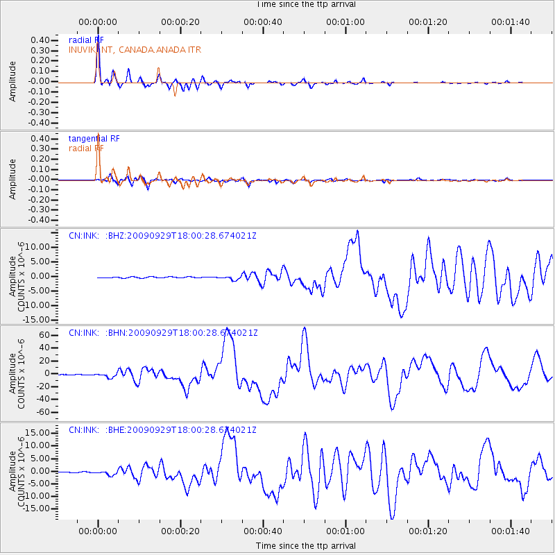
2009/09/29 (272) 17:48:10 GMT |
| Earthquake Depth: |
18 km |
| Earthquake Magnitude: |
7.1 MB, 8.1 MS, 8.1 MW, 8.0 MW |
| Earthquake Catalog/Contributor: |
WHDF/NEIC |
|
| Network: |
CN Canadian National Seismograph Network |
| Station: |
INK INUVIK, NT, CANADA.ANADA |
| Lat/Lon: |
68.31 N/133.52 W |
| Elevation: |
40 m |
|
| Distance: |
88.1 deg |
| Az: |
13.412 deg |
| Baz: |
216.979 deg |
| Ray Param: |
0.04285447 |
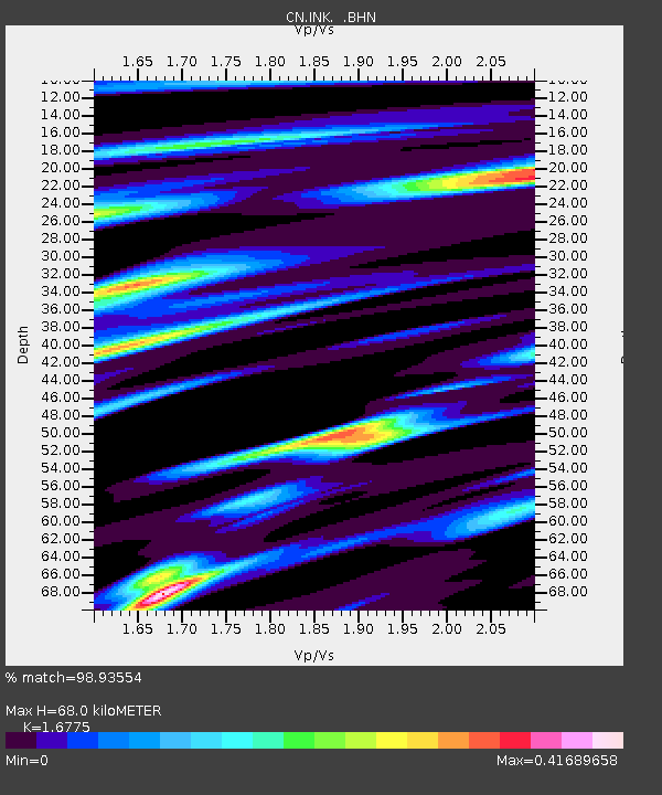
| Estimated Moho Depth: |
68.0 km |
| Estimated Crust Vp/Vs: |
1.68 |
| Assumed Crust Vp: |
6.171 km/s |
| Estimated Crust Vs: |
3.679 km/s |
| Estimated Crust Poisson's Ratio: |
0.22 |
|
| Radial Match: |
98.93554 % |
| Radial Bump: |
292 |
| Transverse Match: |
93.06874 % |
| Transverse Bump: |
400 |
| SOD ConfigId: |
2622 |
| Insert Time: |
2010-02-27 06:19:21.087 +0000 |
| GWidth: |
2.5 |
| Max Bumps: |
400 |
| Tol: |
0.001 |
|
Signal To Noise
| Channel | StoN | STA | LTA |
| CN:INK: :BHN:20090929T18:00:28.674021Z | 18.06045 | 3.3425883E-6 | 1.8507781E-7 |
| CN:INK: :BHE:20090929T18:00:28.674021Z | 5.7965684 | 7.98047E-7 | 1.3767577E-7 |
| CN:INK: :BHZ:20090929T18:00:28.674021Z | 3.3333836 | 6.349683E-7 | 1.9048761E-7 |
| Arrivals |
| Ps | 7.6 SECOND |
| PpPs | 29 SECOND |
| PsPs/PpSs | 37 SECOND |


