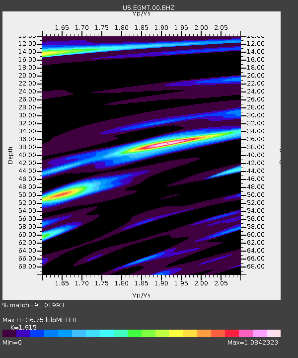
EGMT Eagleton, Montana, USA - Earthquake Result Viewer
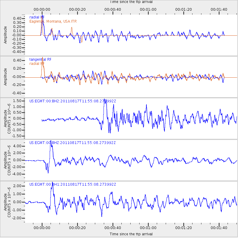
Earthquake location: Off East Coast Of Honshu, Japan
Earthquake latitude/longitude: 36.8/143.8
Earthquake time(UTC): 2011/08/17 (229) 11:44:08 GMT
Earthquake Depth: 9.0 km
Earthquake Magnitude: 6.1 MB, 5.8 MS, 6.2 MW, 6.1 MW
Earthquake Catalog/Contributor: WHDF/NEIC
Network: US United States National Seismic Network
Station: EGMT Eagleton, Montana, USA
Lat/Lon: 48.02 N/109.75 W
Elevation: 1055 m
Distance: 73.2 deg
Az: 42.252 deg
Baz: 306.454 deg
Ray Param: 0.053154767
Estimated Moho Depth: 36.75 km
Estimated Crust Vp/Vs: 1.91
Assumed Crust Vp: 6.438 km/s
Estimated Crust Vs: 3.362 km/s
Estimated Crust Poisson's Ratio: 0.31
Radial Match: 91.01993 %
Radial Bump: 400
Transverse Match: 82.876564 %
Transverse Bump: 400
SOD ConfigId: 558545
Insert Time: 2013-09-19 01:13:08.303 +0000
GWidth: 2.5
Max Bumps: 400
Tol: 0.001

Signal To Noise

ChannelStoNSTALTA
US:EGMT:00:BHZ:20110817T11:55:08.273992Z33.6462141.7536014E-65.2118835E-8
US:EGMT:00:BH1:20110817T11:55:08.273992Z3.97172574.46647E-71.12456654E-7
US:EGMT:00:BH2:20110817T11:55:08.273992Z4.0170923.11952E-77.765617E-8
Arrivals
Ps5.4 SECOND
PpPs16 SECOND
PsPs/PpSs22 SECOND