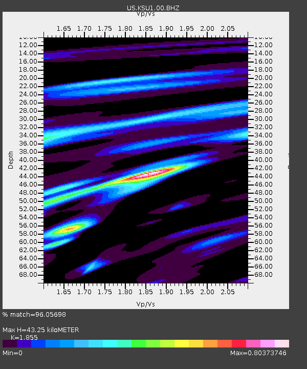
KSU1 Kansas State University--Konza Prairie, Kansas, USA - Earthquake Result Viewer

Earthquake location: Off East Coast Of Honshu, Japan
Earthquake latitude/longitude: 36.8/143.8
Earthquake time(UTC): 2011/08/17 (229) 11:44:08 GMT
Earthquake Depth: 9.0 km
Earthquake Magnitude: 6.1 MB, 5.8 MS, 6.2 MW, 6.1 MW
Earthquake Catalog/Contributor: WHDF/NEIC
Network: US United States National Seismic Network
Station: KSU1 Kansas State University--Konza Prairie, Kansas, USA
Lat/Lon: 39.10 N/96.61 W
Elevation: 347 m
Distance: 86.2 deg
Az: 42.678 deg
Baz: 315.607 deg
Ray Param: 0.044191588
Estimated Moho Depth: 43.25 km
Estimated Crust Vp/Vs: 1.86
Assumed Crust Vp: 6.483 km/s
Estimated Crust Vs: 3.495 km/s
Estimated Crust Poisson's Ratio: 0.30
Radial Match: 96.05698 %
Radial Bump: 400
Transverse Match: 87.8451 %
Transverse Bump: 400
SOD ConfigId: 558545
Insert Time: 2013-09-19 01:13:40.610 +0000
GWidth: 2.5
Max Bumps: 400
Tol: 0.001

Signal To Noise

ChannelStoNSTALTA
US:KSU1:00:BHZ:20110817T11:56:18.698979Z27.6485562.2643442E-68.1897376E-8
US:KSU1:00:BH1:20110817T11:56:18.698979Z5.0506043.9018553E-77.725522E-8
US:KSU1:00:BH2:20110817T11:56:18.698979Z11.4327385.957271E-75.2107122E-8
Arrivals
Ps5.8 SECOND
PpPs19 SECOND
PsPs/PpSs24 SECOND