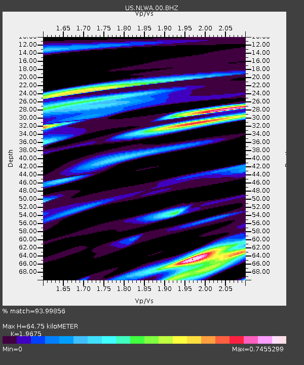
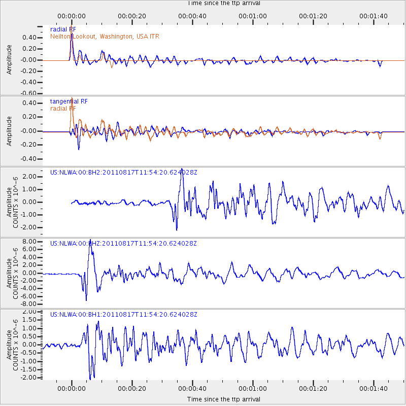
NLWA Neilton Lookout, Washington, USA - Earthquake Result Viewer

Earthquake location: Off East Coast Of Honshu, Japan
Earthquake latitude/longitude: 36.8/143.8
Earthquake time(UTC): 2011/08/17 (229) 11:44:08 GMT
Earthquake Depth: 9.0 km
Earthquake Magnitude: 6.1 MB, 5.8 MS, 6.2 MW, 6.1 MW
Earthquake Catalog/Contributor: WHDF/NEIC
Network: US United States National Seismic Network
Station: NLWA Neilton Lookout, Washington, USA
Lat/Lon: 47.39 N/123.87 W
Elevation: 640 m
Distance: 65.5 deg
Az: 48.252 deg
Baz: 298.143 deg
Ray Param: 0.058237396
Estimated Moho Depth: 64.75 km
Estimated Crust Vp/Vs: 1.97
Assumed Crust Vp: 6.566 km/s
Estimated Crust Vs: 3.337 km/s
Estimated Crust Poisson's Ratio: 0.33
Radial Match: 93.99856 %
Radial Bump: 400
Transverse Match: 90.9097 %
Transverse Bump: 400
SOD ConfigId: 558545
Insert Time: 2013-09-19 01:14:15.947 +0000
GWidth: 2.5
Max Bumps: 400
Tol: 0.001

Signal To Noise

ChannelStoNSTALTA
US:NLWA:00:BHZ:20110817T11:54:20.624028Z21.6722411.8108224E-68.3554916E-8
US:NLWA:00:BH1:20110817T11:54:20.624028Z3.25647042.698056E-78.285216E-8
US:NLWA:00:BH2:20110817T11:54:20.624028Z5.3536975.9488315E-71.1111632E-7
Arrivals
Ps9.9 SECOND
PpPs28 SECOND
PsPs/PpSs38 SECOND