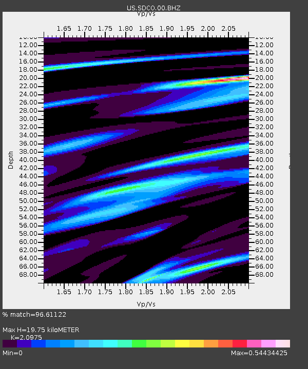
SDCO Great Sand Dunes National Park, Colorado, USA - Earthquake Result Viewer

Earthquake location: Off East Coast Of Honshu, Japan
Earthquake latitude/longitude: 36.8/143.8
Earthquake time(UTC): 2011/08/17 (229) 11:44:08 GMT
Earthquake Depth: 9.0 km
Earthquake Magnitude: 6.1 MB, 5.8 MS, 6.2 MW, 6.1 MW
Earthquake Catalog/Contributor: WHDF/NEIC
Network: US United States National Seismic Network
Station: SDCO Great Sand Dunes National Park, Colorado, USA
Lat/Lon: 37.75 N/105.50 W
Elevation: 2569 m
Distance: 82.1 deg
Az: 48.466 deg
Baz: 310.686 deg
Ray Param: 0.047144722
Estimated Moho Depth: 19.75 km
Estimated Crust Vp/Vs: 2.10
Assumed Crust Vp: 6.316 km/s
Estimated Crust Vs: 3.011 km/s
Estimated Crust Poisson's Ratio: 0.35
Radial Match: 96.61122 %
Radial Bump: 222
Transverse Match: 94.37806 %
Transverse Bump: 400
SOD ConfigId: 558545
Insert Time: 2013-09-19 01:14:34.500 +0000
GWidth: 2.5
Max Bumps: 400
Tol: 0.001

Signal To Noise

ChannelStoNSTALTA
US:SDCO:00:BHZ:20110817T11:55:57.549016Z33.4890981.1357678E-63.3914553E-8
US:SDCO:00:BH1:20110817T11:55:57.549016Z4.43309071.4125555E-73.1863898E-8
US:SDCO:00:BH2:20110817T11:55:57.549016Z10.4553573.8583525E-73.6903117E-8
Arrivals
Ps3.5 SECOND
PpPs9.5 SECOND
PsPs/PpSs13 SECOND