You are here: Home > Network List > CN - Canadian National Seismograph Network Stations List
> Station INK INUVIK, NT, CANADA.ANADA > Earthquake Result Viewer
INK INUVIK, NT, CANADA.ANADA - Earthquake Result Viewer
| Earthquake location: |
Off East Coast Of Kamchatka |
| Earthquake latitude/longitude: |
52.2/159.5 |
| Earthquake time(UTC): |
1998/05/27 (147) 20:41:37 GMT |
| Earthquake Depth: |
60 km |
| Earthquake Magnitude: |
5.5 MB, 6.0 UNKNOWN, 5.9 MW |
| Earthquake Catalog/Contributor: |
WHDF/NEIC |
|
| Network: |
CN Canadian National Seismograph Network |
| Station: |
INK INUVIK, NT, CANADA.ANADA |
| Lat/Lon: |
68.31 N/133.52 W |
| Elevation: |
40 m |
|
| Distance: |
34.8 deg |
| Az: |
36.874 deg |
| Baz: |
277.023 deg |
| Ray Param: |
0.07741642 |
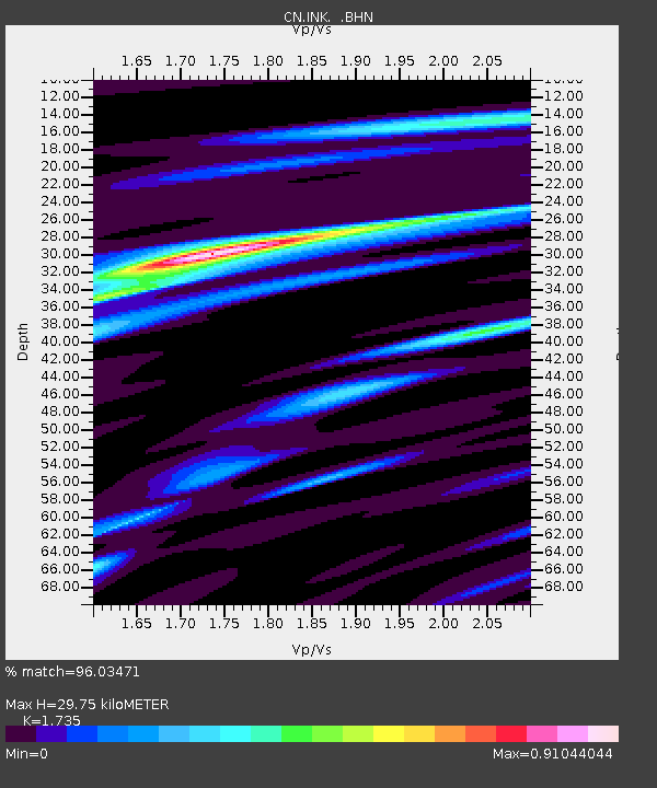
| Estimated Moho Depth: |
29.75 km |
| Estimated Crust Vp/Vs: |
1.74 |
| Assumed Crust Vp: |
6.171 km/s |
| Estimated Crust Vs: |
3.557 km/s |
| Estimated Crust Poisson's Ratio: |
0.25 |
|
| Radial Match: |
96.03471 % |
| Radial Bump: |
243 |
| Transverse Match: |
86.34789 % |
| Transverse Bump: |
400 |
| SOD ConfigId: |
4480 |
| Insert Time: |
2010-02-27 06:19:40.260 +0000 |
| GWidth: |
2.5 |
| Max Bumps: |
400 |
| Tol: |
0.001 |
|
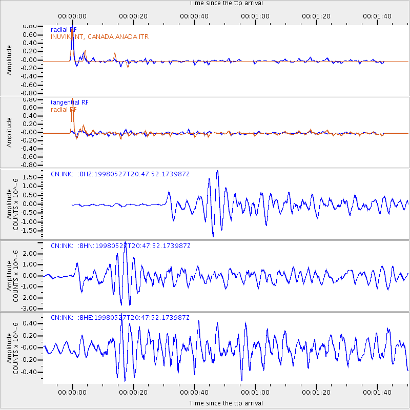
Signal To Noise
| Channel | StoN | STA | LTA |
| CN:INK: :BHN:19980527T20:47:52.173987Z | 7.5956745 | 6.6417357E-7 | 8.744103E-8 |
| CN:INK: :BHE:19980527T20:47:52.173987Z | 2.56765 | 1.0918821E-7 | 4.252457E-8 |
| CN:INK: :BHZ:19980527T20:47:52.173987Z | 10.075219 | 4.196788E-7 | 4.1654555E-8 |
| Arrivals |
| Ps | 3.8 SECOND |
| PpPs | 12 SECOND |
| PsPs/PpSs | 16 SECOND |


