You are here: Home > Network List > US - United States National Seismic Network Stations List
> Station WMOK Wichita Mountains, Oklahoma, USA > Earthquake Result Viewer
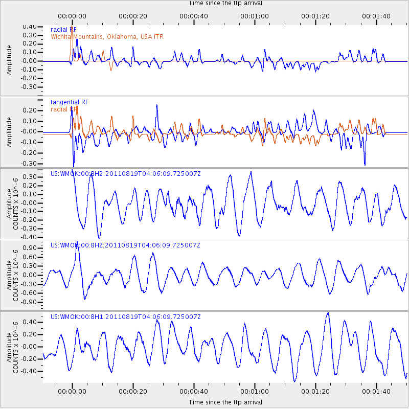
WMOK Wichita Mountains, Oklahoma, USA - Earthquake Result Viewer
*The percent match for this event was below the threshold and hence no stack was calculated.
| Earthquake location: |
Fiji Islands Region |
| Earthquake latitude/longitude: |
-16.5/-177.0 |
| Earthquake time(UTC): |
2011/08/19 (231) 03:54:26 GMT |
| Earthquake Depth: |
408 km |
| Earthquake Magnitude: |
5.5 MB, 6.2 MW, 6.2 MW |
| Earthquake Catalog/Contributor: |
WHDF/NEIC |
|
| Network: |
US United States National Seismic Network |
| Station: |
WMOK Wichita Mountains, Oklahoma, USA |
| Lat/Lon: |
34.74 N/98.78 W |
| Elevation: |
486 m |
|
| Distance: |
89.9 deg |
| Az: |
53.728 deg |
| Baz: |
249.89 deg |
| Ray Param: |
$rayparam |
*The percent match for this event was below the threshold and hence was not used in the summary stack. |
|
| Radial Match: |
66.6619 % |
| Radial Bump: |
400 |
| Transverse Match: |
56.416977 % |
| Transverse Bump: |
400 |
| SOD ConfigId: |
558545 |
| Insert Time: |
2013-09-19 01:17:50.582 +0000 |
| GWidth: |
2.5 |
| Max Bumps: |
400 |
| Tol: |
0.001 |
|
Signal To Noise
| Channel | StoN | STA | LTA |
| US:WMOK:00:BHZ:20110819T04:06:09.725007Z | 2.7905524 | 5.86573E-7 | 2.1019959E-7 |
| US:WMOK:00:BH1:20110819T04:06:09.725007Z | 1.1823528 | 1.9378966E-7 | 1.6390173E-7 |
| US:WMOK:00:BH2:20110819T04:06:09.725007Z | 0.54777765 | 9.999189E-8 | 1.8254102E-7 |
| Arrivals |
| Ps | |
| PpPs | |
| PsPs/PpSs | |


