You are here: Home > Network List > US - United States National Seismic Network Stations List
> Station WUAZ Wupatki, Arizona, USA > Earthquake Result Viewer
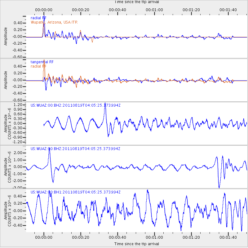
WUAZ Wupatki, Arizona, USA - Earthquake Result Viewer
*The percent match for this event was below the threshold and hence no stack was calculated.
| Earthquake location: |
Fiji Islands Region |
| Earthquake latitude/longitude: |
-16.5/-177.0 |
| Earthquake time(UTC): |
2011/08/19 (231) 03:54:26 GMT |
| Earthquake Depth: |
408 km |
| Earthquake Magnitude: |
5.5 MB, 6.2 MW, 6.2 MW |
| Earthquake Catalog/Contributor: |
WHDF/NEIC |
|
| Network: |
US United States National Seismic Network |
| Station: |
WUAZ Wupatki, Arizona, USA |
| Lat/Lon: |
35.52 N/111.37 W |
| Elevation: |
1592 m |
|
| Distance: |
80.8 deg |
| Az: |
48.827 deg |
| Baz: |
242.262 deg |
| Ray Param: |
$rayparam |
*The percent match for this event was below the threshold and hence was not used in the summary stack. |
|
| Radial Match: |
73.388664 % |
| Radial Bump: |
400 |
| Transverse Match: |
70.054146 % |
| Transverse Bump: |
400 |
| SOD ConfigId: |
558545 |
| Insert Time: |
2013-09-19 01:17:54.561 +0000 |
| GWidth: |
2.5 |
| Max Bumps: |
400 |
| Tol: |
0.001 |
|
Signal To Noise
| Channel | StoN | STA | LTA |
| US:WUAZ:00:BHZ:20110819T04:05:25.373994Z | 4.5422115 | 1.1133445E-6 | 2.4511067E-7 |
| US:WUAZ:00:BH1:20110819T04:05:25.373994Z | 2.2796829 | 3.2556295E-7 | 1.4281063E-7 |
| US:WUAZ:00:BH2:20110819T04:05:25.373994Z | 1.8918843 | 5.1975843E-7 | 2.7473055E-7 |
| Arrivals |
| Ps | |
| PpPs | |
| PsPs/PpSs | |


