You are here: Home > Network List > US - United States National Seismic Network Stations List
> Station ACSO Alum Creek State Park, Ohio, USA > Earthquake Result Viewer
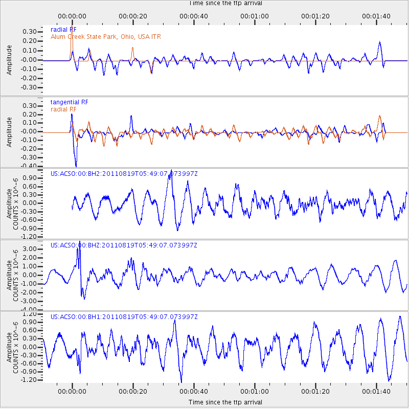
ACSO Alum Creek State Park, Ohio, USA - Earthquake Result Viewer
*The percent match for this event was below the threshold and hence no stack was calculated.
| Earthquake location: |
Near East Coast Of Honshu, Japan |
| Earthquake latitude/longitude: |
37.7/141.7 |
| Earthquake time(UTC): |
2011/08/19 (231) 05:36:33 GMT |
| Earthquake Depth: |
47 km |
| Earthquake Magnitude: |
6.3 MB, 5.9 MS, 6.3 MW, 6.3 MW |
| Earthquake Catalog/Contributor: |
WHDF/NEIC |
|
| Network: |
US United States National Seismic Network |
| Station: |
ACSO Alum Creek State Park, Ohio, USA |
| Lat/Lon: |
40.23 N/82.98 W |
| Elevation: |
288 m |
|
| Distance: |
92.3 deg |
| Az: |
32.569 deg |
| Baz: |
326.085 deg |
| Ray Param: |
$rayparam |
*The percent match for this event was below the threshold and hence was not used in the summary stack. |
|
| Radial Match: |
62.90289 % |
| Radial Bump: |
400 |
| Transverse Match: |
85.30972 % |
| Transverse Bump: |
318 |
| SOD ConfigId: |
558545 |
| Insert Time: |
2013-09-19 01:19:57.645 +0000 |
| GWidth: |
2.5 |
| Max Bumps: |
400 |
| Tol: |
0.001 |
|
Signal To Noise
| Channel | StoN | STA | LTA |
| US:ACSO:00:BHZ:20110819T05:49:07.073997Z | 3.9177582 | 1.778106E-6 | 4.53858E-7 |
| US:ACSO:00:BH1:20110819T05:49:07.073997Z | 1.2784681 | 3.8896903E-7 | 3.0424616E-7 |
| US:ACSO:00:BH2:20110819T05:49:07.073997Z | 2.3643622 | 6.9881975E-7 | 2.9556375E-7 |
| Arrivals |
| Ps | |
| PpPs | |
| PsPs/PpSs | |


