You are here: Home > Network List > CN - Canadian National Seismograph Network Stations List
> Station INK INUVIK, NT, CANADA.ANADA > Earthquake Result Viewer
INK INUVIK, NT, CANADA.ANADA - Earthquake Result Viewer

| Earthquake location: |
Off East Coast Of Kamchatka |
| Earthquake latitude/longitude: |
52.9/160.1 |
| Earthquake time(UTC): |
1998/06/01 (152) 05:34:03 GMT |
| Earthquake Depth: |
44 km |
| Earthquake Magnitude: |
6.2 MB, 6.3 MS, 6.5 UNKNOWN, 6.4 MW |
| Earthquake Catalog/Contributor: |
WHDF/NEIC |
|
| Network: |
CN Canadian National Seismograph Network |
| Station: |
INK INUVIK, NT, CANADA.ANADA |
| Lat/Lon: |
68.31 N/133.52 W |
| Elevation: |
40 m |
|
| Distance: |
34.0 deg |
| Az: |
37.493 deg |
| Baz: |
277.254 deg |
| Ray Param: |
0.07784138 |
| Estimated Moho Depth: |
27.25 km |
| Estimated Crust Vp/Vs: |
1.88 |
| Assumed Crust Vp: |
6.171 km/s |
| Estimated Crust Vs: |
3.274 km/s |
| Estimated Crust Poisson's Ratio: |
0.30 |
|
| Radial Match: |
97.41855 % |
| Radial Bump: |
267 |
| Transverse Match: |
86.66963 % |
| Transverse Bump: |
400 |
| SOD ConfigId: |
4480 |
| Insert Time: |
2010-02-27 06:19:50.699 +0000 |
| GWidth: |
2.5 |
| Max Bumps: |
400 |
| Tol: |
0.001 |
|
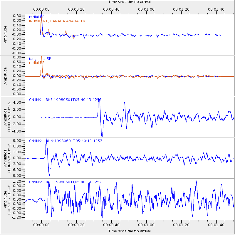
Signal To Noise
| Channel | StoN | STA | LTA |
| CN:INK: :BHN:19980601T05:40:13.125Z | 52.60504 | 4.479229E-6 | 8.514829E-8 |
| CN:INK: :BHE:19980601T05:40:13.125Z | 7.75002 | 5.470829E-7 | 7.0591156E-8 |
| CN:INK: :BHZ:19980601T05:40:13.125Z | 34.4222 | 2.7681988E-6 | 8.0419E-8 |
| Arrivals |
| Ps | 4.2 SECOND |
| PpPs | 12 SECOND |
| PsPs/PpSs | 16 SECOND |


