You are here: Home > Network List > US - United States National Seismic Network Stations List
> Station DGMT Dagmar, Montana, USA > Earthquake Result Viewer
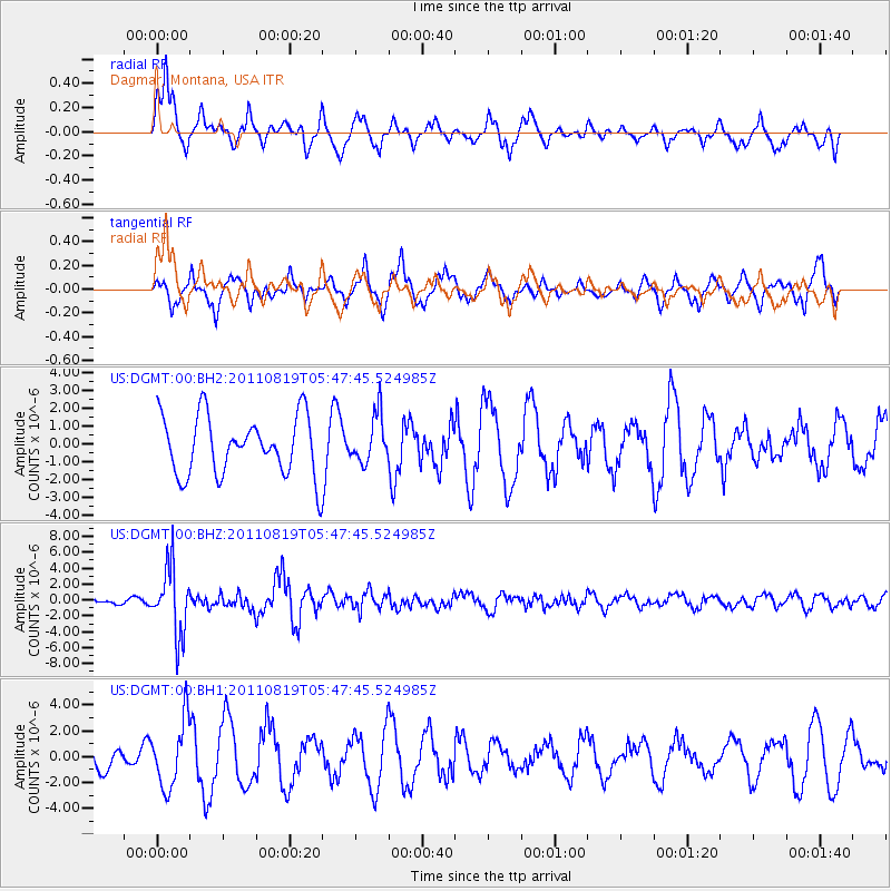
DGMT Dagmar, Montana, USA - Earthquake Result Viewer
*The percent match for this event was below the threshold and hence no stack was calculated.
| Earthquake location: |
Near East Coast Of Honshu, Japan |
| Earthquake latitude/longitude: |
37.7/141.7 |
| Earthquake time(UTC): |
2011/08/19 (231) 05:36:33 GMT |
| Earthquake Depth: |
47 km |
| Earthquake Magnitude: |
6.3 MB, 5.9 MS, 6.3 MW, 6.3 MW |
| Earthquake Catalog/Contributor: |
WHDF/NEIC |
|
| Network: |
US United States National Seismic Network |
| Station: |
DGMT Dagmar, Montana, USA |
| Lat/Lon: |
48.47 N/104.20 W |
| Elevation: |
0.0 m |
|
| Distance: |
76.2 deg |
| Az: |
38.699 deg |
| Baz: |
311.798 deg |
| Ray Param: |
$rayparam |
*The percent match for this event was below the threshold and hence was not used in the summary stack. |
|
| Radial Match: |
66.90069 % |
| Radial Bump: |
388 |
| Transverse Match: |
74.18435 % |
| Transverse Bump: |
394 |
| SOD ConfigId: |
558545 |
| Insert Time: |
2013-09-19 01:20:24.541 +0000 |
| GWidth: |
2.5 |
| Max Bumps: |
400 |
| Tol: |
0.001 |
|
Signal To Noise
| Channel | StoN | STA | LTA |
| US:DGMT:00:BHZ:20110819T05:47:45.524985Z | 11.286045 | 4.2679426E-6 | 3.7816102E-7 |
| US:DGMT:00:BH1:20110819T05:47:45.524985Z | 2.0172474 | 2.576928E-6 | 1.2774477E-6 |
| US:DGMT:00:BH2:20110819T05:47:45.524985Z | 0.80971867 | 1.3438993E-6 | 1.6597113E-6 |
| Arrivals |
| Ps | |
| PpPs | |
| PsPs/PpSs | |


