You are here: Home > Network List > TA - USArray Transportable Network (new EarthScope stations) Stations List
> Station M51A Elyria, OH, USA > Earthquake Result Viewer
M51A Elyria, OH, USA - Earthquake Result Viewer
*The percent match for this event was below the threshold and hence no stack was calculated.
| Earthquake location: |
Easter Island Region |
| Earthquake latitude/longitude: |
-26.8/-114.6 |
| Earthquake time(UTC): |
2014/09/06 (249) 08:37:45 GMT |
| Earthquake Depth: |
10 km |
| Earthquake Magnitude: |
5.1 mb |
| Earthquake Catalog/Contributor: |
ISC/ISC |
|
| Network: |
TA USArray Transportable Network (new EarthScope stations) |
| Station: |
M51A Elyria, OH, USA |
| Lat/Lon: |
41.33 N/82.18 W |
| Elevation: |
239 m |
|
| Distance: |
74.1 deg |
| Az: |
24.79 deg |
| Baz: |
209.847 deg |
| Ray Param: |
$rayparam |
*The percent match for this event was below the threshold and hence was not used in the summary stack. |
|
| Radial Match: |
65.261055 % |
| Radial Bump: |
400 |
| Transverse Match: |
38.159435 % |
| Transverse Bump: |
400 |
| SOD ConfigId: |
3390531 |
| Insert Time: |
2019-04-13 21:48:51.229 +0000 |
| GWidth: |
2.5 |
| Max Bumps: |
400 |
| Tol: |
0.001 |
|
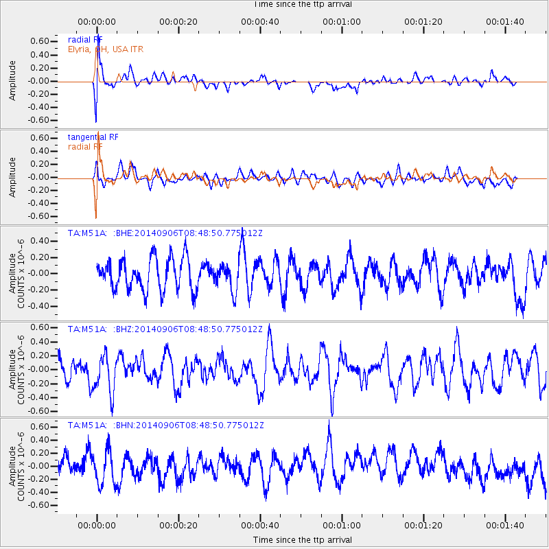
Signal To Noise
| Channel | StoN | STA | LTA |
| TA:M51A: :BHZ:20140906T08:48:50.775012Z | 1.7030342 | 2.7370345E-7 | 1.6071519E-7 |
| TA:M51A: :BHN:20140906T08:48:50.775012Z | 1.7422818 | 2.6844972E-7 | 1.540794E-7 |
| TA:M51A: :BHE:20140906T08:48:50.775012Z | 0.8637581 | 1.6834518E-7 | 1.9489853E-7 |
| Arrivals |
| Ps | |
| PpPs | |
| PsPs/PpSs | |


