You are here: Home > Network List > US - United States National Seismic Network Stations List
> Station ERPA Erie, Pennsylvania, USA > Earthquake Result Viewer
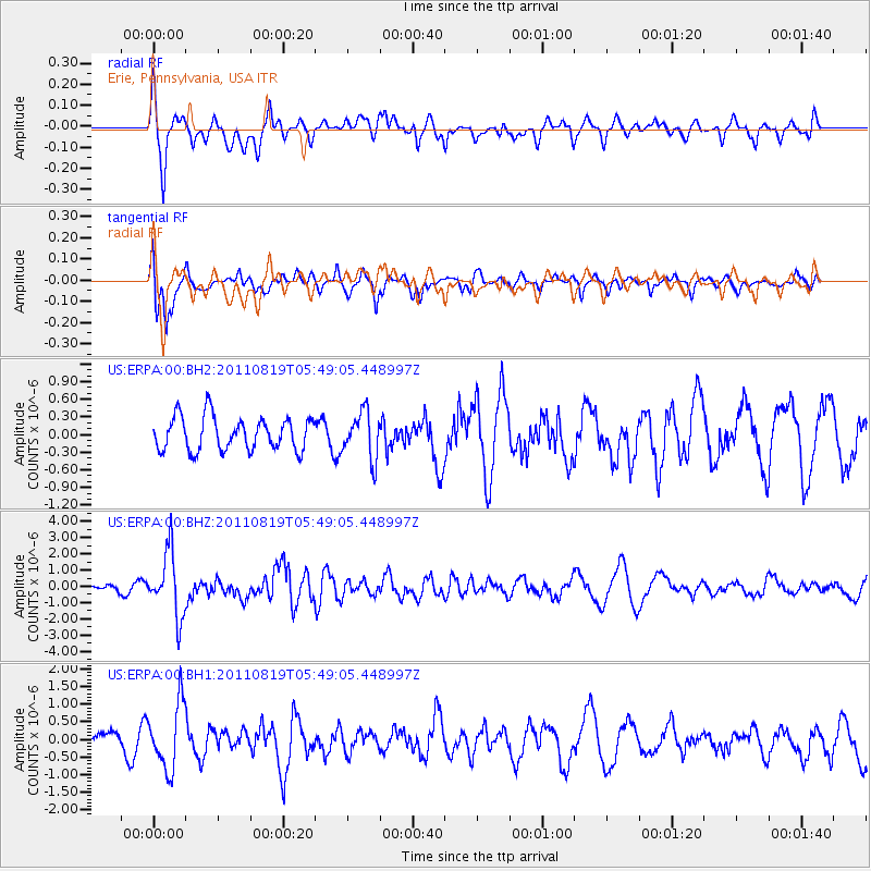
ERPA Erie, Pennsylvania, USA - Earthquake Result Viewer
*The percent match for this event was below the threshold and hence no stack was calculated.
| Earthquake location: |
Near East Coast Of Honshu, Japan |
| Earthquake latitude/longitude: |
37.7/141.7 |
| Earthquake time(UTC): |
2011/08/19 (231) 05:36:33 GMT |
| Earthquake Depth: |
47 km |
| Earthquake Magnitude: |
6.3 MB, 5.9 MS, 6.3 MW, 6.3 MW |
| Earthquake Catalog/Contributor: |
WHDF/NEIC |
|
| Network: |
US United States National Seismic Network |
| Station: |
ERPA Erie, Pennsylvania, USA |
| Lat/Lon: |
42.12 N/79.99 W |
| Elevation: |
306 m |
|
| Distance: |
92.0 deg |
| Az: |
29.647 deg |
| Baz: |
328.158 deg |
| Ray Param: |
$rayparam |
*The percent match for this event was below the threshold and hence was not used in the summary stack. |
|
| Radial Match: |
65.731155 % |
| Radial Bump: |
400 |
| Transverse Match: |
66.85924 % |
| Transverse Bump: |
400 |
| SOD ConfigId: |
558545 |
| Insert Time: |
2013-09-19 01:20:39.143 +0000 |
| GWidth: |
2.5 |
| Max Bumps: |
400 |
| Tol: |
0.001 |
|
Signal To Noise
| Channel | StoN | STA | LTA |
| US:ERPA:00:BHZ:20110819T05:49:05.448997Z | 5.4372654 | 1.9641145E-6 | 3.6123205E-7 |
| US:ERPA:00:BH1:20110819T05:49:05.448997Z | 2.464494 | 9.297532E-7 | 3.7725925E-7 |
| US:ERPA:00:BH2:20110819T05:49:05.448997Z | 1.4063932 | 3.9384E-7 | 2.800355E-7 |
| Arrivals |
| Ps | |
| PpPs | |
| PsPs/PpSs | |


