You are here: Home > Network List > US - United States National Seismic Network Stations List
> Station LONY Lake Ozonia, New York, USA > Earthquake Result Viewer
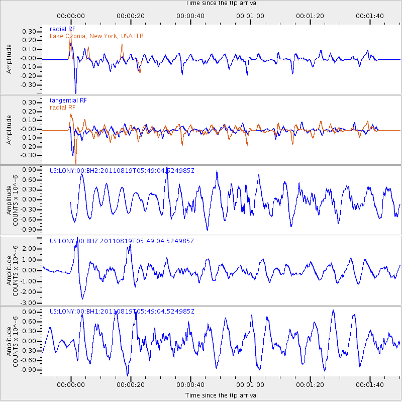
LONY Lake Ozonia, New York, USA - Earthquake Result Viewer
*The percent match for this event was below the threshold and hence no stack was calculated.
| Earthquake location: |
Near East Coast Of Honshu, Japan |
| Earthquake latitude/longitude: |
37.7/141.7 |
| Earthquake time(UTC): |
2011/08/19 (231) 05:36:33 GMT |
| Earthquake Depth: |
47 km |
| Earthquake Magnitude: |
6.3 MB, 5.9 MS, 6.3 MW, 6.3 MW |
| Earthquake Catalog/Contributor: |
WHDF/NEIC |
|
| Network: |
US United States National Seismic Network |
| Station: |
LONY Lake Ozonia, New York, USA |
| Lat/Lon: |
44.62 N/74.58 W |
| Elevation: |
440 m |
|
| Distance: |
91.8 deg |
| Az: |
24.982 deg |
| Baz: |
332.013 deg |
| Ray Param: |
$rayparam |
*The percent match for this event was below the threshold and hence was not used in the summary stack. |
|
| Radial Match: |
73.42815 % |
| Radial Bump: |
383 |
| Transverse Match: |
55.273663 % |
| Transverse Bump: |
400 |
| SOD ConfigId: |
558545 |
| Insert Time: |
2013-09-19 01:21:20.146 +0000 |
| GWidth: |
2.5 |
| Max Bumps: |
400 |
| Tol: |
0.001 |
|
Signal To Noise
| Channel | StoN | STA | LTA |
| US:LONY:00:BHZ:20110819T05:49:04.524985Z | 3.362323 | 1.6932767E-6 | 5.036032E-7 |
| US:LONY:00:BH1:20110819T05:49:04.524985Z | 0.93484 | 3.8178186E-7 | 4.083927E-7 |
| US:LONY:00:BH2:20110819T05:49:04.524985Z | 1.2895513 | 4.4180968E-7 | 3.426073E-7 |
| Arrivals |
| Ps | |
| PpPs | |
| PsPs/PpSs | |


