You are here: Home > Network List > IU - Global Seismograph Network (GSN - IRIS/USGS) Stations List
> Station GUMO Guam, Mariana Islands > Earthquake Result Viewer
GUMO Guam, Mariana Islands - Earthquake Result Viewer
| Earthquake location: |
Vanuatu Islands |
| Earthquake latitude/longitude: |
-18.4/168.1 |
| Earthquake time(UTC): |
2011/08/20 (232) 16:55:02 GMT |
| Earthquake Depth: |
32 km |
| Earthquake Magnitude: |
6.2 MB, 7.1 MS, 7.1 MW, 7.0 MW |
| Earthquake Catalog/Contributor: |
WHDF/NEIC |
|
| Network: |
IU Global Seismograph Network (GSN - IRIS/USGS) |
| Station: |
GUMO Guam, Mariana Islands |
| Lat/Lon: |
13.59 N/144.87 E |
| Elevation: |
170 m |
|
| Distance: |
39.2 deg |
| Az: |
322.541 deg |
| Baz: |
143.557 deg |
| Ray Param: |
0.07507393 |
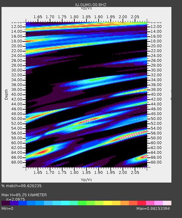
| Estimated Moho Depth: |
65.25 km |
| Estimated Crust Vp/Vs: |
2.10 |
| Assumed Crust Vp: |
4.802 km/s |
| Estimated Crust Vs: |
2.289 km/s |
| Estimated Crust Poisson's Ratio: |
0.35 |
|
| Radial Match: |
89.628235 % |
| Radial Bump: |
369 |
| Transverse Match: |
78.815315 % |
| Transverse Bump: |
400 |
| SOD ConfigId: |
558545 |
| Insert Time: |
2013-09-19 01:26:35.283 +0000 |
| GWidth: |
2.5 |
| Max Bumps: |
400 |
| Tol: |
0.001 |
|

Signal To Noise
| Channel | StoN | STA | LTA |
| IU:GUMO:00:BHZ:20110820T17:01:57.269015Z | 4.5199447 | 2.7261804E-6 | 6.031446E-7 |
| IU:GUMO:00:BH1:20110820T17:01:57.269015Z | 1.7314353 | 2.2628253E-6 | 1.3069072E-6 |
| IU:GUMO:00:BH2:20110820T17:01:57.269015Z | 1.1389097 | 1.2070024E-6 | 1.0597876E-6 |
| Arrivals |
| Ps | 15 SECOND |
| PpPs | 41 SECOND |
| PsPs/PpSs | 56 SECOND |


