You are here: Home > Network List > US - United States National Seismic Network Stations List
> Station HAWA Hanford, Washington, USA > Earthquake Result Viewer
HAWA Hanford, Washington, USA - Earthquake Result Viewer

| Earthquake location: |
Vanuatu Islands |
| Earthquake latitude/longitude: |
-18.4/168.1 |
| Earthquake time(UTC): |
2011/08/20 (232) 16:55:02 GMT |
| Earthquake Depth: |
32 km |
| Earthquake Magnitude: |
6.2 MB, 7.1 MS, 7.1 MW, 7.0 MW |
| Earthquake Catalog/Contributor: |
WHDF/NEIC |
|
| Network: |
US United States National Seismic Network |
| Station: |
HAWA Hanford, Washington, USA |
| Lat/Lon: |
46.39 N/119.53 W |
| Elevation: |
364 m |
|
| Distance: |
91.5 deg |
| Az: |
41.277 deg |
| Baz: |
244.848 deg |
| Ray Param: |
0.041589934 |
| Estimated Moho Depth: |
32.0 km |
| Estimated Crust Vp/Vs: |
1.92 |
| Assumed Crust Vp: |
6.419 km/s |
| Estimated Crust Vs: |
3.335 km/s |
| Estimated Crust Poisson's Ratio: |
0.32 |
|
| Radial Match: |
96.18218 % |
| Radial Bump: |
343 |
| Transverse Match: |
85.11859 % |
| Transverse Bump: |
400 |
| SOD ConfigId: |
558545 |
| Insert Time: |
2013-09-19 01:27:15.687 +0000 |
| GWidth: |
2.5 |
| Max Bumps: |
400 |
| Tol: |
0.001 |
|
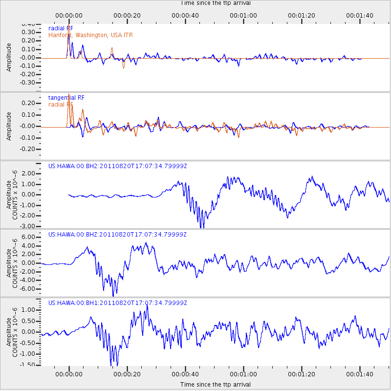
Signal To Noise
| Channel | StoN | STA | LTA |
| US:HAWA:00:BHZ:20110820T17:07:34.79999Z | 15.598475 | 1.3549726E-6 | 8.6865704E-8 |
| US:HAWA:00:BH1:20110820T17:07:34.79999Z | 2.4341104 | 1.541918E-7 | 6.334626E-8 |
| US:HAWA:00:BH2:20110820T17:07:34.79999Z | 5.9078712 | 3.7078607E-7 | 6.2761366E-8 |
| Arrivals |
| Ps | 4.7 SECOND |
| PpPs | 14 SECOND |
| PsPs/PpSs | 19 SECOND |


