You are here: Home > Network List > US - United States National Seismic Network Stations List
> Station MNTX Cornudas Mountains, Texas, USA > Earthquake Result Viewer
MNTX Cornudas Mountains, Texas, USA - Earthquake Result Viewer
| Earthquake location: |
Vanuatu Islands |
| Earthquake latitude/longitude: |
-18.4/168.1 |
| Earthquake time(UTC): |
2011/08/20 (232) 16:55:02 GMT |
| Earthquake Depth: |
32 km |
| Earthquake Magnitude: |
6.2 MB, 7.1 MS, 7.1 MW, 7.0 MW |
| Earthquake Catalog/Contributor: |
WHDF/NEIC |
|
| Network: |
US United States National Seismic Network |
| Station: |
MNTX Cornudas Mountains, Texas, USA |
| Lat/Lon: |
31.70 N/105.38 W |
| Elevation: |
404 m |
|
| Distance: |
96.5 deg |
| Az: |
58.911 deg |
| Baz: |
252.577 deg |
| Ray Param: |
0.040468097 |
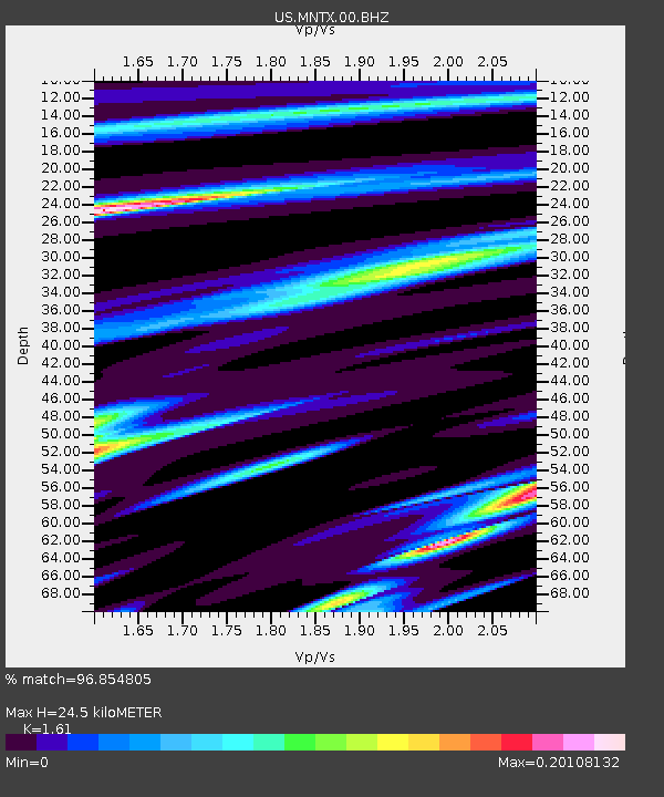
| Estimated Moho Depth: |
24.5 km |
| Estimated Crust Vp/Vs: |
1.61 |
| Assumed Crust Vp: |
6.361 km/s |
| Estimated Crust Vs: |
3.951 km/s |
| Estimated Crust Poisson's Ratio: |
0.19 |
|
| Radial Match: |
96.854805 % |
| Radial Bump: |
350 |
| Transverse Match: |
76.23006 % |
| Transverse Bump: |
400 |
| SOD ConfigId: |
558545 |
| Insert Time: |
2013-09-19 01:27:21.683 +0000 |
| GWidth: |
2.5 |
| Max Bumps: |
400 |
| Tol: |
0.001 |
|

Signal To Noise
| Channel | StoN | STA | LTA |
| US:MNTX:00:BHZ:20110820T17:07:57.724978Z | 11.426745 | 6.8867973E-7 | 6.02691E-8 |
| US:MNTX:00:BH1:20110820T17:07:57.724978Z | 0.97279894 | 5.1940926E-8 | 5.339328E-8 |
| US:MNTX:00:BH2:20110820T17:07:57.724978Z | 3.3471727 | 2.598112E-7 | 7.7621095E-8 |
| Arrivals |
| Ps | 2.4 SECOND |
| PpPs | 9.8 SECOND |
| PsPs/PpSs | 12 SECOND |


