You are here: Home > Network List > US - United States National Seismic Network Stations List
> Station HAWA Hanford, Washington, USA > Earthquake Result Viewer
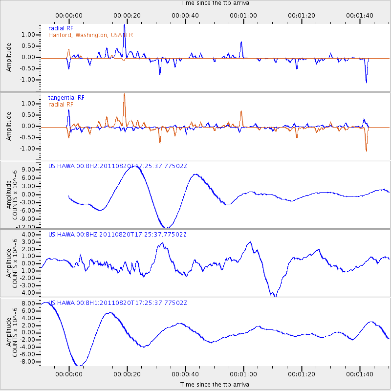
HAWA Hanford, Washington, USA - Earthquake Result Viewer
*The percent match for this event was below the threshold and hence no stack was calculated.
| Earthquake location: |
Vanuatu Islands |
| Earthquake latitude/longitude: |
-18.3/168.2 |
| Earthquake time(UTC): |
2011/08/20 (232) 17:13:06 GMT |
| Earthquake Depth: |
35 km |
| Earthquake Magnitude: |
5.9 MB, 6.5 MW |
| Earthquake Catalog/Contributor: |
WHDF/NEIC |
|
| Network: |
US United States National Seismic Network |
| Station: |
HAWA Hanford, Washington, USA |
| Lat/Lon: |
46.39 N/119.53 W |
| Elevation: |
364 m |
|
| Distance: |
91.5 deg |
| Az: |
41.272 deg |
| Baz: |
244.876 deg |
| Ray Param: |
$rayparam |
*The percent match for this event was below the threshold and hence was not used in the summary stack. |
|
| Radial Match: |
45.30569 % |
| Radial Bump: |
203 |
| Transverse Match: |
37.13862 % |
| Transverse Bump: |
351 |
| SOD ConfigId: |
558545 |
| Insert Time: |
2013-09-19 01:29:00.873 +0000 |
| GWidth: |
2.5 |
| Max Bumps: |
400 |
| Tol: |
0.001 |
|
Signal To Noise
| Channel | StoN | STA | LTA |
| US:HAWA:00:BHZ:20110820T17:25:37.77502Z | 0.27165884 | 4.290187E-7 | 1.5792556E-6 |
| US:HAWA:00:BH1:20110820T17:25:37.77502Z | 1.5997429 | 7.5873827E-6 | 4.7428766E-6 |
| US:HAWA:00:BH2:20110820T17:25:37.77502Z | 1.8656125 | 1.0753737E-5 | 5.7641855E-6 |
| Arrivals |
| Ps | |
| PpPs | |
| PsPs/PpSs | |


