You are here: Home > Network List > IU - Global Seismograph Network (GSN - IRIS/USGS) Stations List
> Station TATO Taipei, Taiwan > Earthquake Result Viewer
TATO Taipei, Taiwan - Earthquake Result Viewer
| Earthquake location: |
Vanuatu Islands |
| Earthquake latitude/longitude: |
-18.3/168.2 |
| Earthquake time(UTC): |
2011/08/20 (232) 18:19:23 GMT |
| Earthquake Depth: |
28 km |
| Earthquake Magnitude: |
6.4 MB, 7.1 MS, 7.1 MW, 7.0 MW |
| Earthquake Catalog/Contributor: |
WHDF/NEIC |
|
| Network: |
IU Global Seismograph Network (GSN - IRIS/USGS) |
| Station: |
TATO Taipei, Taiwan |
| Lat/Lon: |
24.97 N/121.50 E |
| Elevation: |
160 m |
|
| Distance: |
62.6 deg |
| Az: |
311.916 deg |
| Baz: |
128.84 deg |
| Ray Param: |
0.06006811 |
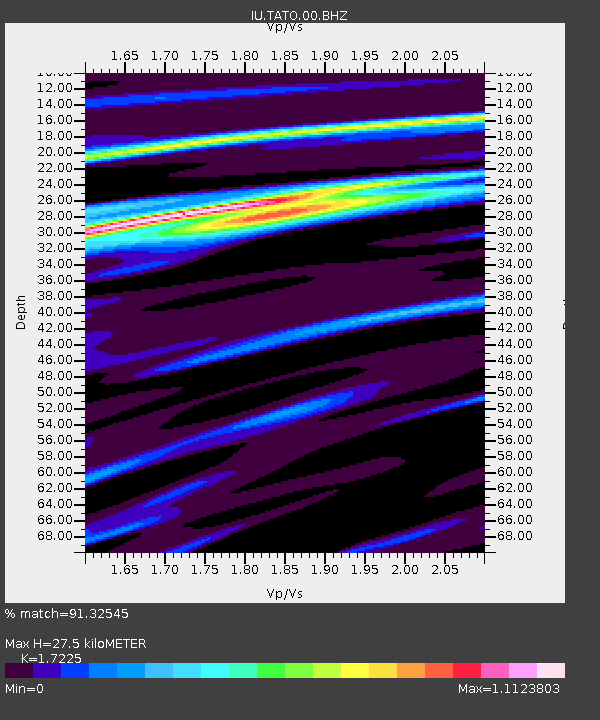
| Estimated Moho Depth: |
27.5 km |
| Estimated Crust Vp/Vs: |
1.72 |
| Assumed Crust Vp: |
6.289 km/s |
| Estimated Crust Vs: |
3.651 km/s |
| Estimated Crust Poisson's Ratio: |
0.25 |
|
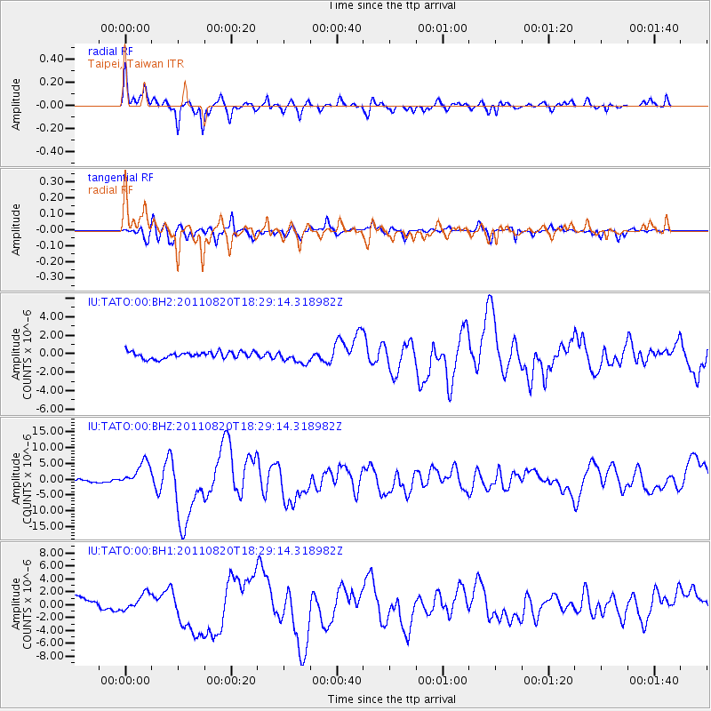
| Radial Match: |
91.32545 % |
| Radial Bump: |
390 |
| Transverse Match: |
60.490562 % |
| Transverse Bump: |
400 |
| SOD ConfigId: |
558545 |
| Insert Time: |
2013-09-19 01:30:15.164 +0000 |
| GWidth: |
2.5 |
| Max Bumps: |
400 |
| Tol: |
0.001 |
|
Signal To Noise
| Channel | StoN | STA | LTA |
| IU:TATO:00:BHZ:20110820T18:29:14.318982Z | 4.373052 | 3.8957173E-6 | 8.908463E-7 |
| IU:TATO:00:BH1:20110820T18:29:14.318982Z | 1.1214006 | 1.3050256E-6 | 1.1637461E-6 |
| IU:TATO:00:BH2:20110820T18:29:14.318982Z | 2.0074708 | 7.0478904E-7 | 3.5108306E-7 |
| Arrivals |
| Ps | 3.3 SECOND |
| PpPs | 11 SECOND |
| PsPs/PpSs | 15 SECOND |


