You are here: Home > Network List > II - Global Seismograph Network (GSN - IRIS/IDA) Stations List
> Station PFO Pinon Flat, California, USA > Earthquake Result Viewer
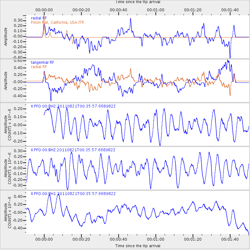
PFO Pinon Flat, California, USA - Earthquake Result Viewer
*The percent match for this event was below the threshold and hence no stack was calculated.
| Earthquake location: |
Vanuatu Islands |
| Earthquake latitude/longitude: |
-18.2/167.9 |
| Earthquake time(UTC): |
2011/08/21 (233) 00:23:39 GMT |
| Earthquake Depth: |
35 km |
| Earthquake Magnitude: |
5.6 MW, 5.5 MB, 5.6 MW |
| Earthquake Catalog/Contributor: |
NEIC PDE/NEIC PDE-M |
|
| Network: |
II Global Seismograph Network (GSN - IRIS/IDA) |
| Station: |
PFO Pinon Flat, California, USA |
| Lat/Lon: |
33.61 N/116.46 W |
| Elevation: |
1280 m |
|
| Distance: |
88.6 deg |
| Az: |
53.982 deg |
| Baz: |
247.09 deg |
| Ray Param: |
$rayparam |
*The percent match for this event was below the threshold and hence was not used in the summary stack. |
|
| Radial Match: |
45.09957 % |
| Radial Bump: |
400 |
| Transverse Match: |
34.44228 % |
| Transverse Bump: |
400 |
| SOD ConfigId: |
558545 |
| Insert Time: |
2013-09-19 01:31:11.856 +0000 |
| GWidth: |
2.5 |
| Max Bumps: |
400 |
| Tol: |
0.001 |
|
Signal To Noise
| Channel | StoN | STA | LTA |
| II:PFO:00:BHZ:20110821T00:35:57.668982Z | 0.7726966 | 1.06849726E-7 | 1.382816E-7 |
| II:PFO:00:BH1:20110821T00:35:57.668982Z | 1.8763669 | 3.044798E-7 | 1.6227094E-7 |
| II:PFO:00:BH2:20110821T00:35:57.668982Z | 0.8773817 | 1.0580568E-7 | 1.2059253E-7 |
| Arrivals |
| Ps | |
| PpPs | |
| PsPs/PpSs | |


