You are here: Home > Network List > CN - Canadian National Seismograph Network Stations List
> Station INK INUVIK, NT, CANADA.ANADA > Earthquake Result Viewer
INK INUVIK, NT, CANADA.ANADA - Earthquake Result Viewer
| Earthquake location: |
Off Coast Of Central America |
| Earthquake latitude/longitude: |
11.7/-88.0 |
| Earthquake time(UTC): |
1998/08/23 (235) 13:57:15 GMT |
| Earthquake Depth: |
55 km |
| Earthquake Magnitude: |
5.7 MB, 6.3 MS, 6.8 UNKNOWN, 6.7 MW |
| Earthquake Catalog/Contributor: |
WHDF/NEIC |
|
| Network: |
CN Canadian National Seismograph Network |
| Station: |
INK INUVIK, NT, CANADA.ANADA |
| Lat/Lon: |
68.31 N/133.52 W |
| Elevation: |
40 m |
|
| Distance: |
63.8 deg |
| Az: |
342.812 deg |
| Baz: |
128.866 deg |
| Ray Param: |
0.0592289 |
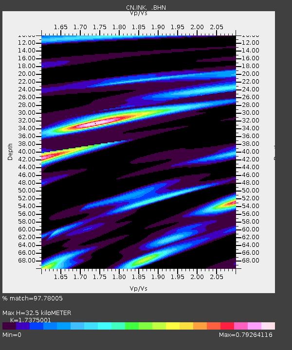
| Estimated Moho Depth: |
32.5 km |
| Estimated Crust Vp/Vs: |
1.74 |
| Assumed Crust Vp: |
6.171 km/s |
| Estimated Crust Vs: |
3.552 km/s |
| Estimated Crust Poisson's Ratio: |
0.25 |
|
| Radial Match: |
97.78005 % |
| Radial Bump: |
312 |
| Transverse Match: |
88.788994 % |
| Transverse Bump: |
400 |
| SOD ConfigId: |
4480 |
| Insert Time: |
2010-02-27 06:20:31.657 +0000 |
| GWidth: |
2.5 |
| Max Bumps: |
400 |
| Tol: |
0.001 |
|

Signal To Noise
| Channel | StoN | STA | LTA |
| CN:INK: :BHN:19980823T14:07:10.849011Z | 40.875164 | 2.7442893E-6 | 6.713831E-8 |
| CN:INK: :BHE:19980823T14:07:10.849011Z | 12.86243 | 8.9261806E-7 | 6.9397316E-8 |
| CN:INK: :BHZ:19980823T14:07:10.849011Z | 19.772665 | 1.0090981E-6 | 5.1035006E-8 |
| Arrivals |
| Ps | 4.0 SECOND |
| PpPs | 14 SECOND |
| PsPs/PpSs | 18 SECOND |


