You are here: Home > Network List > CN - Canadian National Seismograph Network Stations List
> Station INK INUVIK, NT, CANADA.ANADA > Earthquake Result Viewer
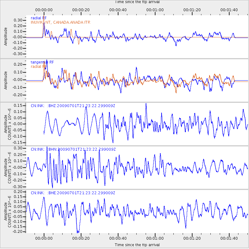
INK INUVIK, NT, CANADA.ANADA - Earthquake Result Viewer
*The percent match for this event was below the threshold and hence no stack was calculated.
| Earthquake location: |
Northern Molucca Sea |
| Earthquake latitude/longitude: |
1.1/126.0 |
| Earthquake time(UTC): |
2009/07/01 (182) 21:10:44 GMT |
| Earthquake Depth: |
37 km |
| Earthquake Magnitude: |
5.7 MB, 5.3 MS, 5.8 MW, 5.8 MW |
| Earthquake Catalog/Contributor: |
WHDF/NEIC |
|
| Network: |
CN Canadian National Seismograph Network |
| Station: |
INK INUVIK, NT, CANADA.ANADA |
| Lat/Lon: |
68.31 N/133.52 W |
| Elevation: |
40 m |
|
| Distance: |
92.9 deg |
| Az: |
21.47 deg |
| Baz: |
280.162 deg |
| Ray Param: |
$rayparam |
*The percent match for this event was below the threshold and hence was not used in the summary stack. |
|
| Radial Match: |
57.86295 % |
| Radial Bump: |
400 |
| Transverse Match: |
44.115173 % |
| Transverse Bump: |
395 |
| SOD ConfigId: |
2622 |
| Insert Time: |
2010-02-27 06:20:40.385 +0000 |
| GWidth: |
2.5 |
| Max Bumps: |
400 |
| Tol: |
0.001 |
|
Signal To Noise
| Channel | StoN | STA | LTA |
| CN:INK: :BHN:20090701T21:23:22.299009Z | 2.5589166 | 1.5845558E-7 | 6.192292E-8 |
| CN:INK: :BHE:20090701T21:23:22.299009Z | 1.5323397 | 8.4829686E-8 | 5.5359585E-8 |
| CN:INK: :BHZ:20090701T21:23:22.299009Z | 1.1251627 | 5.965025E-8 | 5.3014777E-8 |
| Arrivals |
| Ps | |
| PpPs | |
| PsPs/PpSs | |


