You are here: Home > Network List > II - Global Seismograph Network (GSN - IRIS/IDA) Stations List
> Station CMLA Cha de Macela, Sao Miguel Island, Azores > Earthquake Result Viewer
CMLA Cha de Macela, Sao Miguel Island, Azores - Earthquake Result Viewer
| Earthquake location: |
Peru-Brazil Border Region |
| Earthquake latitude/longitude: |
-7.6/-74.5 |
| Earthquake time(UTC): |
2011/08/24 (236) 17:46:11 GMT |
| Earthquake Depth: |
147 km |
| Earthquake Magnitude: |
6.8 MB, 7.0 MW, 7.0 MW |
| Earthquake Catalog/Contributor: |
WHDF/NEIC |
|
| Network: |
II Global Seismograph Network (GSN - IRIS/IDA) |
| Station: |
CMLA Cha de Macela, Sao Miguel Island, Azores |
| Lat/Lon: |
37.76 N/25.52 W |
| Elevation: |
429 m |
|
| Distance: |
64.2 deg |
| Az: |
41.622 deg |
| Baz: |
236.176 deg |
| Ray Param: |
0.058643296 |
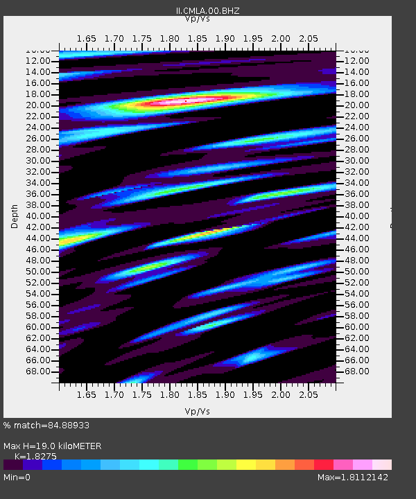
| Estimated Moho Depth: |
19.0 km |
| Estimated Crust Vp/Vs: |
1.83 |
| Assumed Crust Vp: |
4.802 km/s |
| Estimated Crust Vs: |
2.628 km/s |
| Estimated Crust Poisson's Ratio: |
0.29 |
|
| Radial Match: |
84.88933 % |
| Radial Bump: |
400 |
| Transverse Match: |
82.11838 % |
| Transverse Bump: |
400 |
| SOD ConfigId: |
558545 |
| Insert Time: |
2013-09-19 01:45:34.140 +0000 |
| GWidth: |
2.5 |
| Max Bumps: |
400 |
| Tol: |
0.001 |
|

Signal To Noise
| Channel | StoN | STA | LTA |
| II:CMLA:00:BHZ:20110824T17:56:00.118994Z | 15.236684 | 9.37649E-6 | 6.153892E-7 |
| II:CMLA:00:BH1:20110824T17:56:00.118994Z | 4.1635823 | 3.781221E-6 | 9.081653E-7 |
| II:CMLA:00:BH2:20110824T17:56:00.118994Z | 4.850637 | 4.499616E-6 | 9.2763406E-7 |
| Arrivals |
| Ps | 3.3 SECOND |
| PpPs | 11 SECOND |
| PsPs/PpSs | 14 SECOND |


